IMAGES TAKEN NEAR TO
Ricket Lane, MANSFIELD, NG21 0ND
Introduction
This page details the photographs taken nearby to Ricket Lane, NG21 0ND by members of the Geograph project.
The Geograph project started in 2005 with the aim of publishing, organising and preserving representative images for every square kilometre of Great Britain, Ireland and the Isle of Man.

There are currently over 7.5m images from over14,400 individuals and you can help contribute to the project by visiting https://www.geograph.org.uk
Image Map
Images are licensed for reuse under creativecommons.org/licenses/by-sa/2.0
Notes
- Clicking on the map will re-center to the selected point.
- The higher the marker number, the further away the image location is from the centre of the postcode.
Image Listing (19 Images Found)
Images are licensed for reuse under creativecommons.org/licenses/by-sa/2.0
Image
Details
Distance
2
View to The Coach House, Fountain Dale
Image: © Neil Theasby
Taken: 30 Dec 2020
0.02 miles
3
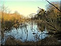
Lake in Fountain Dale
To my untrained eye, this looks like an environmental disaster. However, this is shown as a lake on the map, so I suppose those trees shouldn't have been growing there anyway . . .
Image: © Antony Dixon
Taken: 27 Dec 2011
0.05 miles
5
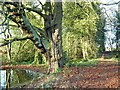
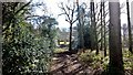
Forest path, with impressive horse chestnut tree
Image: © Antony Dixon
Taken: 27 Dec 2011
0.07 miles
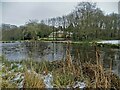
6
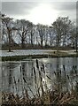
View over one of the large ponds in Fountain Dale
Image: © Neil Theasby
Taken: 30 Dec 2020
0.08 miles
7
Lake near Friar Tuck's Well in Fountain Dale
Robin Hood tales and place name references abound across Nottinghamshire, Derbyshire and South Yorkshire, but you get a genuinely authentic sense of the legend in this particular valley.
Image: © Jonathan Clitheroe
Taken: 8 Oct 2022
0.08 miles
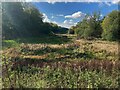
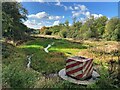
8
Moat in Fountain Dale
Marked on the map as an 'antiquity' it is thought to have been built in Saxon times to protect a shrine. It is said that the relics and treasures of the shrine were hidden by a monk when the Danes were raiding the area, and were never found, possibly because the monk who hid them was killed.
Image: © Antony Dixon
Taken: 27 Dec 2011
0.11 miles
9
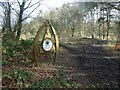
Robin Hood Way information panel in Harlow Wood
The panel tells the legend of Robin Hood who, according to a 16th century ballad, first met Friar Tuck near here at Fountain Dale
Image: © Graham Hogg
Taken: 22 Feb 2016
0.12 miles
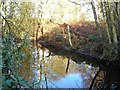
10
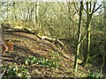
Embankment and moat in Fountain Dale
This is the part of the feature closest to the path. The moat (dry at the time I was there) is in the shadows to the right of the picture. See Image for more information.
Image: © Antony Dixon
Taken: 27 Dec 2011
0.12 miles