IMAGES TAKEN NEAR TO
Webster Close, MANSFIELD, NG21 0FS
Introduction
This page details the photographs taken nearby to Webster Close, NG21 0FS by members of the Geograph project.
The Geograph project started in 2005 with the aim of publishing, organising and preserving representative images for every square kilometre of Great Britain, Ireland and the Isle of Man.

There are currently over 7.5m images from over14,400 individuals and you can help contribute to the project by visiting https://www.geograph.org.uk
Image Map
Images are licensed for reuse under creativecommons.org/licenses/by-sa/2.0
Notes
- Clicking on the map will re-center to the selected point.
- The higher the marker number, the further away the image location is from the centre of the postcode.
Image Listing (11 Images Found)
Images are licensed for reuse under creativecommons.org/licenses/by-sa/2.0
Image
Details
Distance
1
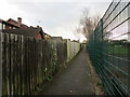
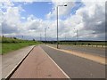
Footpath behind Briar Close, Rainworth
Image: © Jonathan Thacker
Taken: 12 Jan 2020
0.05 miles
2
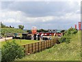
Housing development site yard
This is the site yard for Davidsons Lavender Fields housing development, between the A617 and the B6020 Kirklington Road in Rainworth. http://www.davidsonsgroup.co.uk/new-homes-for-sale/rainworth-mansfield-nottinghamshire/
In the background can be seen some wind turbines in Image
Image: © David P Howard
Taken: 15 Jun 2012
0.18 miles
3
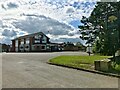
The Sherwood
A typical mid-20th Century estate pub on the outskirts of Rainworth. Built in the late '60s or early '70s I would guess.
Image: © David Lally
Taken: 31 Aug 2023
0.18 miles

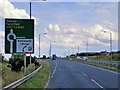
6
Lay by on A617
Looking west from a lay by on a dual carriageway section of the A617 near Rainworth.
Image: © David P Howard
Taken: 15 Jun 2012
0.21 miles
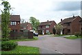
8
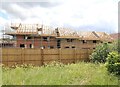
New housing development
A number of new houses being built between the A617 and the B6020 Kirklington Road in Rainworth.
This is part of Davidsons Lavender Fields development. http://www.davidsonsgroup.co.uk/new-homes-for-sale/rainworth-mansfield-nottinghamshire/
Image: © David P Howard
Taken: 15 Jun 2012
0.22 miles

10
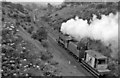
Blidworth & Rainworth Station (remains)
View NW, towards Mansfield. Station (remains) are in left distance, ahead of the Engine (a Stanier Class 8F 2-8-0) and brake. This is the ex-Midland Mansfield - Rolleston Junction line in its last throes, having lost its passenger service on 12/8/29 and closing completely on 1/2/65.
Image: © Ben Brooksbank
Taken: 12 Jul 1963
0.22 miles