IMAGES TAKEN NEAR TO
Helmsley Road, MANSFIELD, NG21 0DG
Introduction
This page details the photographs taken nearby to Helmsley Road, NG21 0DG by members of the Geograph project.
The Geograph project started in 2005 with the aim of publishing, organising and preserving representative images for every square kilometre of Great Britain, Ireland and the Isle of Man.

There are currently over 7.5m images from over14,400 individuals and you can help contribute to the project by visiting https://www.geograph.org.uk
Image Map
Images are licensed for reuse under creativecommons.org/licenses/by-sa/2.0
Notes
- Clicking on the map will re-center to the selected point.
- The higher the marker number, the further away the image location is from the centre of the postcode.
Image Listing (8 Images Found)
Images are licensed for reuse under creativecommons.org/licenses/by-sa/2.0
Image
Details
Distance
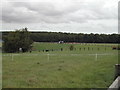
4
Helmsley Road, Rainworth, Notts.
The northern end of Helmsley Road peters out here shortly after a driveway - on the left - provides access into the extensive grounds of Dawn House School. Dawn House is Dawn House School is a special school for children and young people of between 5-19 years with a severe or complex communication difficulties or Asperger’s Syndrome. Ahead lies Clipstone Forest and beyond that, Strawberry Hill Heath (a 23 hectare Site of Special Scientific Interest) (SSSI).
Image: © David Hallam-Jones
Taken: 11 Jan 2015
0.09 miles
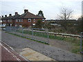
5
Helmsley Road, Rainworth, Notts.
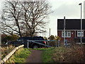
Here the Mansfield Way (a medium distance trail) is approaching Helmsley Road where walkers wishing to continue to follow the trail need to cross this residential road and to descend on the opposite side of it to pick up former route used by the Mansfield-Southwell Railway. A 2.5 mile long railway was built from Rolleston Junction on the Nottingham-Lincoln line to Southwell in 1847. In April 1871 the line was extended to Mansfield. This extension helped further development of the coalfield east of Mansfield, so much so that the increasing amount of coal-related traffic resulted in the whole line being doubled in the 1920s. The line closed to passengers in 1959.
Image: © David Hallam-Jones
Taken: 11 Jan 2015
0.09 miles
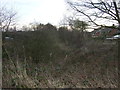
6
Dawn House School, Helmsley Road, Rainworth, Notts.
A left hand gateway at the northern end (i.e. the cul-de-sac end) of Helmsley Road provides access into the extensive grounds of Dawn House School. Dawn House is a special school for children and young people of between 5-19 years with a severe or complex communication difficulties or Asperger’s Syndrome. To the north of the school grounds, along a forestry track extension of Helmsley Road is a path that leads into Clipstone Forest.
Image: © David Hallam-Jones
Taken: 11 Jan 2015
0.10 miles
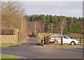
7
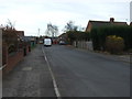
Helmsley Road
Heading south towards the B6020.
Image: © JThomas
Taken: 17 Mar 2014
0.13 miles
8
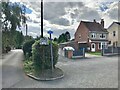
An erroneous NCN sign?
For NCN Route 6 without brackets. This implying that tis is on the route. However, Route 6 does not go along here and I don't think it ever did. With brackets it should be pointing in the other direction too!
Image: © David Lally
Taken: 31 Aug 2023
0.22 miles