IMAGES TAKEN NEAR TO
Cuckney Road, MANSFIELD, NG20 9JF
Introduction
This page details the photographs taken nearby to Cuckney Road, NG20 9JF by members of the Geograph project.
The Geograph project started in 2005 with the aim of publishing, organising and preserving representative images for every square kilometre of Great Britain, Ireland and the Isle of Man.

There are currently over 7.5m images from over14,400 individuals and you can help contribute to the project by visiting https://www.geograph.org.uk
Image Map
Images are licensed for reuse under creativecommons.org/licenses/by-sa/2.0
Notes
- Clicking on the map will re-center to the selected point.
- The higher the marker number, the further away the image location is from the centre of the postcode.
Image Listing (33 Images Found)
Images are licensed for reuse under creativecommons.org/licenses/by-sa/2.0
Image
Details
Distance
1
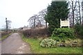
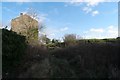
Goff's Restaurant, Langwith
Lane leading to Goff's Restaurant at Langwith Mill House. Also showing the old mill building.
Image: © Ann B
Taken: 2 Jan 2006
0.00 miles
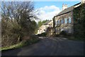
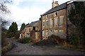
3
Langwith Mill House
Once a grand house beside Langwith cotton mill. More recently Goff's Restaurant, but the present evidence suggests vandalism, arson, dilapidation and dereliction. Plenty of scope for restoration - but to be used for what?
Image: © Chris Morgan
Taken: 17 Jan 2014
0.00 miles
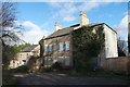
5
Langwith Mill House
Adjacent to a former cotton mill. Now derelict, it is hard to believe that this house was a restaurant in the not too distant past Image
Image: © Graham Hogg
Taken: 17 Jan 2014
0.01 miles
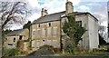
6
Langwith Mill House
Boarded up and falling into disrepair is this Georgian house, which (unlike the adjacent mill it is so obviously associated with) is actually a grade II listed building, although that seems to have done it little good. It is, however, currently up for sale so it may be saved.
see https://www.historicengland.org.uk/listing/the-list/list-entry/1224043
Image: © Bob Harvey
Taken: 29 Jan 2016
0.01 miles
7
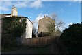
Langwith house and mill
On the left the end of the house in Image
On the right the gable end of the industrial building in Image
Image: © Bob Harvey
Taken: 29 Jan 2016
0.02 miles
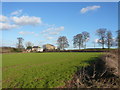
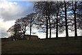
8
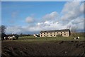
Cattle near the mill
Farm animals living in front of the old watermill
Next to Image can be seen the chimneys and roof of Image
Image: © Bob Harvey
Taken: 29 Jan 2016
0.02 miles
9
Track to the mill
End elevation of the crumbling building in Image
The flat-topped field on the right is the one containing animals in Image The landscape here appears artificial. I think that the road past the house is a natural old stream-course, but this slope up to the mill is a constructed access road.
Image: © Bob Harvey
Taken: 29 Jan 2016
0.02 miles
10
Langwith Mill
Former cotton mill on the River Poulter at Nether Langwith, now derelict.
Image: © Graham Hogg
Taken: 17 Jan 2014
0.02 miles