IMAGES TAKEN NEAR TO
Langwith, MANSFIELD, NG20 9JD
Introduction
This page details the photographs taken nearby to NG20 9JD by members of the Geograph project.
The Geograph project started in 2005 with the aim of publishing, organising and preserving representative images for every square kilometre of Great Britain, Ireland and the Isle of Man.

There are currently over 7.5m images from over14,400 individuals and you can help contribute to the project by visiting https://www.geograph.org.uk
Image Map
Images are licensed for reuse under creativecommons.org/licenses/by-sa/2.0
Notes
- Clicking on the map will re-center to the selected point.
- The higher the marker number, the further away the image location is from the centre of the postcode.
Image Listing (6 Images Found)
Images are licensed for reuse under creativecommons.org/licenses/by-sa/2.0
Image
Details
Distance
3
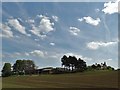
Blue Barn Farm
Stands on a low ridge.
Image: © Jonathan Thacker
Taken: 26 May 2018
0.03 miles
4
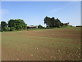
House near Blue Barn Farm
Stands in a fairly isolated position.
Image: © Jonathan Thacker
Taken: 26 May 2018
0.10 miles
5
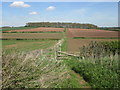
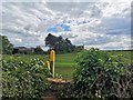
Footpath west of Blue Barn Farm
Graves Wood in the distance
Image: © John Slater
Taken: 4 May 2016
0.14 miles
6
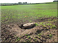
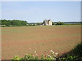
What the plough turned up
This won't have done the plough much good, though I'm surprised that the farmer hasn't removed it before sowing.
Image: © Jonathan Thacker
Taken: 26 May 2018
0.20 miles