IMAGES TAKEN NEAR TO
Avocet Place, MANSFIELD, NG20 8XZ
Introduction
This page details the photographs taken nearby to Avocet Place, NG20 8XZ by members of the Geograph project.
The Geograph project started in 2005 with the aim of publishing, organising and preserving representative images for every square kilometre of Great Britain, Ireland and the Isle of Man.

There are currently over 7.5m images from over14,400 individuals and you can help contribute to the project by visiting https://www.geograph.org.uk
Image Map
Images are licensed for reuse under creativecommons.org/licenses/by-sa/2.0
Notes
- Clicking on the map will re-center to the selected point.
- The higher the marker number, the further away the image location is from the centre of the postcode.
Image Listing (46 Images Found)
Images are licensed for reuse under creativecommons.org/licenses/by-sa/2.0
Image
Details
Distance
1
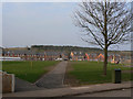
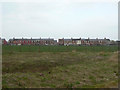
Warsop Vale
View across the green from West Street. The north and east sides of the village are being redeveloped with new housing. This is a view looking roughly north north east, so the houses on the north side are on East Street, a nice whimsey continuing the odd naming of the existing streets - West Street on the south side and North Street on the west side. The east side of the village has always been named King Street.
The new housing is aimed at revitalised what had become a depressed and desolate community following closure of the local colliery in 1989.
Image: © Alan Murray-Rust
Taken: 27 Mar 2011
0.03 miles
2
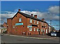
Corner of Greenshank Road and West Street
In Warsop Vale. The corner building was once the home of Warsop Vale Mini Market - no longer operating. It was also the home of the Malcolm Sargison Resource Centre which has also closed indefinitely.
Image: © Neil Theasby
Taken: 4 Nov 2021
0.08 miles
3
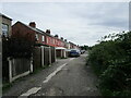
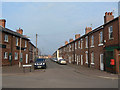
The rear of houses, North Street, Warsop Vale
Image: © Jonathan Thacker
Taken: 14 Aug 2021
0.08 miles
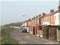
4
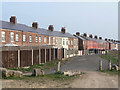
North Street, Warsop Vale
The forms, naturally, the west side of the village. The terraces of cottages were built for the adjacent Warsop Main colliery. The track is designated as a public bridleway.
Image: © Alan Murray-Rust
Taken: 27 Mar 2011
0.08 miles
5
Old postbox at Warsop Vale
It's unclear why this box should have been abandoned and replaced with a new one http://www.geograph.org.uk/photo/2335524. It is built into what is now the Malcolm Sargison Centre, the local community services point.
Image: © Alan Murray-Rust
Taken: 27 Mar 2011
0.08 miles
6
West Street, Warsop Vale
Warsop Vale was a mining village created around 1900 by the Staveley Iron and Steel Company to serve their expanding Warsop Main Colliery. Planned as a square round a large green, of which West Street formed the . . . er . . . south side.
Image: © Alan Murray-Rust
Taken: 27 Mar 2011
0.08 miles
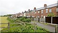
7
North Street, Warsop Vale
The forms, naturally, the west side of the village. This side was intended to be the front of the houses, but their relationship with the rest of the village means that the other side has become the main approach side.
Image: © Alan Murray-Rust
Taken: 27 Mar 2011
0.08 miles
9
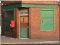
Closed shop on the corner of West Street
The old mining village of Warsop Vale is without any form of retail premises. The postbox (Warsop Vale ref. NG20 83) replaces a wallbox in the building opposite, which still remains in situ http://www.geograph.org.uk/photo/2335530.
Image: © Alan Murray-Rust
Taken: 27 Mar 2011
0.09 miles
10
North Street, Warsop Vale
Seen from one of the branch paths of the Dukeries Trail. It actually forms the west side of the village.
Image: © Alan Murray-Rust
Taken: 27 Mar 2011
0.09 miles