IMAGES TAKEN NEAR TO
Carter Lane, MANSFIELD, NG20 8XF
Introduction
This page details the photographs taken nearby to Carter Lane, NG20 8XF by members of the Geograph project.
The Geograph project started in 2005 with the aim of publishing, organising and preserving representative images for every square kilometre of Great Britain, Ireland and the Isle of Man.

There are currently over 7.5m images from over14,400 individuals and you can help contribute to the project by visiting https://www.geograph.org.uk
Image Map
Images are licensed for reuse under creativecommons.org/licenses/by-sa/2.0
Notes
- Clicking on the map will re-center to the selected point.
- The higher the marker number, the further away the image location is from the centre of the postcode.
Image Listing (25 Images Found)
Images are licensed for reuse under creativecommons.org/licenses/by-sa/2.0
Image
Details
Distance
1
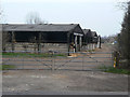
Stock sheds
On Carter Lane near Warsop Vale.
Image: © Alan Murray-Rust
Taken: 27 Mar 2011
0.06 miles
2
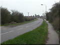
Carter Lane near Warsop Vale
This section of the road is shown as Off Lane on early maps.
Image: © Alan Murray-Rust
Taken: 27 Mar 2011
0.09 miles
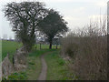
3
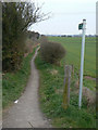
Footpath near Rock House
The first hundred metres or so of this path are asphalted which implies that it must have been of importance at some stage. The likely answer is that it provided a direct pedestrian route between Market Warsop via the Stone Bridge to the large Warsop Main colliery.
Image: © Alan Murray-Rust
Taken: 27 Mar 2011
0.11 miles
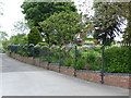
5
Footpath near Church Warsop
Marked on early OS maps as a Bridle Path, but no longer designated as such.
Image: © Alan Murray-Rust
Taken: 27 Mar 2011
0.12 miles
6
Warsop Energy Park
Small generating station using methane from the former Warsop Main colliery. The sign proclaims 'Harnessing renewable energy', although this cannot be claimed for this site. The methane is still part of the fossil deposit.
Image: © Alan Murray-Rust
Taken: 27 Mar 2011
0.12 miles
7
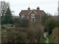
Rock House
This first appears on OS maps by 1920. The adjacent bus stop is labelled 'Cliff House' but there is no property of that name marked.
Image: © Alan Murray-Rust
Taken: 27 Mar 2011
0.12 miles
8
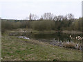
Pond alongside Carter Lane
This is the result of reclamation of the filter beds of the former Warsop Main colliery.
Image: © Alan Murray-Rust
Taken: 27 Mar 2011
0.13 miles
9
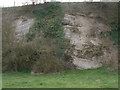
Sandstone strata
There is a marked change in the dip of the strata either side of the growth of ivy - does it conceal a fault line? Exposed as a result of quarrying.
Image: © Alan Murray-Rust
Taken: 27 Mar 2011
0.14 miles
10
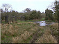
River Meden crossings
Ford for farm vehicles and pipe bridge for sewage at the bottom end of Sookholme Moor.
Image: © Alan Murray-Rust
Taken: 27 Mar 2011
0.14 miles