IMAGES TAKEN NEAR TO
Carter Lane, MANSFIELD, NG20 8XD
Introduction
This page details the photographs taken nearby to Carter Lane, NG20 8XD by members of the Geograph project.
The Geograph project started in 2005 with the aim of publishing, organising and preserving representative images for every square kilometre of Great Britain, Ireland and the Isle of Man.

There are currently over 7.5m images from over14,400 individuals and you can help contribute to the project by visiting https://www.geograph.org.uk
Image Map
Images are licensed for reuse under creativecommons.org/licenses/by-sa/2.0
Notes
- Clicking on the map will re-center to the selected point.
- The higher the marker number, the further away the image location is from the centre of the postcode.
Image Listing (34 Images Found)
Images are licensed for reuse under creativecommons.org/licenses/by-sa/2.0
Image
Details
Distance
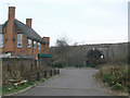
1
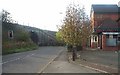
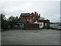
Vale Hotel, Warsop Vale
The Vale Hotel at Warsop Vale, known locally as 'The Swing'. Also showing the road to Shirebrook going through the railway bridge.
Image: © Ann B
Taken: 16 Oct 2005
0.02 miles
2
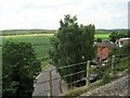
Crossing Carter Lane by train
This was the former Lancashire Derbyshire and East Coast Railway line, which was open to freight between Shirebrook and High Marnham, when this image was taken.
Image: © Nigel Thompson
Taken: 14 Jun 2017
0.03 miles
3
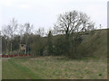
William Wood Bridge
Seen from the south. The railway line is the former Chesterfield and Lincoln line of the old Great Central Railway which has been a freight only line for decades.
Image: © Alan Murray-Rust
Taken: 27 Mar 2011
0.03 miles
5
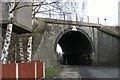
William Wood Bridge
Railway bridge crossing Carter Lane with the Vale Hotel on the left.
Image: © Alan Murray-Rust
Taken: 27 Mar 2011
0.04 miles
6
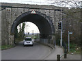
William Wood Bridge
Railway bridge crossing Carter Lane. The Network Rail sign refers to it as carter Lane bridge, but OS maps give the name as William Wood Bridge. The roadway has been narrowed to provide a safe pedestrian route, so with the sharp bends restricting visibility the provision of traffic lights is a very sensible precaution.
Image: © Alan Murray-Rust
Taken: 27 Mar 2011
0.04 miles
8
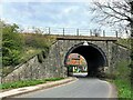
Railway Bridge in Warsop Vale
Railway bridge crossing Carter Lane which is also referred to as William Wood Bridge. Through the arches we can see the Warsop Vale Hotel.
Image: © Jonathan Clitheroe
Taken: 19 Apr 2022
0.05 miles
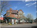
10
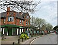
The Warsop Vale Hotel
Public House, known locally as 'The Swing'. The selection of late 70's- early 80's sign fonts on the pub's exterior walls is becoming a rarer sight these days. Also visible here is a local Stagecoach bus service winding its way through the village.
Image: © Jonathan Clitheroe
Taken: 19 Apr 2022
0.06 miles