IMAGES TAKEN NEAR TO
Langwith Road, MANSFIELD, NG20 8TG
Introduction
This page details the photographs taken nearby to Langwith Road, NG20 8TG by members of the Geograph project.
The Geograph project started in 2005 with the aim of publishing, organising and preserving representative images for every square kilometre of Great Britain, Ireland and the Isle of Man.

There are currently over 7.5m images from over14,400 individuals and you can help contribute to the project by visiting https://www.geograph.org.uk
Image Map
Images are licensed for reuse under creativecommons.org/licenses/by-sa/2.0
Notes
- Clicking on the map will re-center to the selected point.
- The higher the marker number, the further away the image location is from the centre of the postcode.
Image Listing (41 Images Found)
Images are licensed for reuse under creativecommons.org/licenses/by-sa/2.0
Image
Details
Distance
2
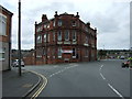
The Station Hotel
Now providing accommodation to the largely migrant labour force of Sports Direct (who have a huge warehouse in the town) as evidenced by the sign advertising rooms to rent Image
Image: © Graham Hogg
Taken: 31 May 2016
0.07 miles
3
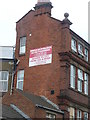
Rooms to Let
A dual language sign on the Station Hotel Image Presumably intended for employees at the nearby Sports Direct warehouse, many of whom are from the EU.
Image: © Graham Hogg
Taken: 31 May 2016
0.07 miles

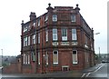
5

Station Hotel, Shirebrook
This must have seen better days. Today rooms are available from £65 a week! (At this time good hotels not too far away may be charging £100 a night.) Polish workers at nearby Sports Direct are being targetted. A neighbouring building was offering rooms at £60, including free wi-fi.
Image: © Chris Morgan
Taken: 31 May 2016
0.08 miles
6

Willow Tree Farm Shirebrook
Play area with animal shelters behind
Image: © norman griffin
Taken: 9 Jul 2010
0.11 miles
7
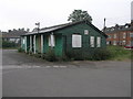
Shirebrook Staff Sports and Social Club
It is not clear where the staff are from but I would not be surprised to discover a railway connection given the proximity to Langwith Junction.
Image: © Michael Patterson
Taken: 12 Sep 2006
0.12 miles
8
Shirebrook - Approaching the Railway Station
Image: © Alan Heardman
Taken: 12 Oct 2008
0.13 miles
9
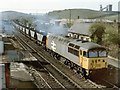
Railway Station, Shirebrook
56018 runs through the former Shirebrook Station. 58024 & 58034 stand in the depot's sidings. Shirebrook Colliery is in the background.
Compare the photograph with this one taken by Ben Brooksbank, 33-years earlier http://www.geograph.org.uk/photo/2122691
Image: © Dave Hitchborne
Taken: 19 Apr 1990
0.13 miles
10
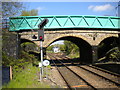
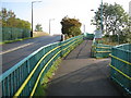
Railway north from Shirebrook station
Immediately north of the bridge carrying Station Road across the railway lies Shirebrook Junction, complete with signal box. The curve to the right links to the remains of the Lancashire, Derbyshire and East Coast Railway's line to Lincoln, part of which survived to provide rail access to various collieries; the rails appear disused, presumably as the closure of Thoresby Colliery in 2015 leaves the line without purpose.
Image: © Richard Vince
Taken: 5 May 2018
0.14 miles