IMAGES TAKEN NEAR TO
Brook Park East Road, MANSFIELD, NG20 8RY
Introduction
This page details the photographs taken nearby to Brook Park East Road, NG20 8RY by members of the Geograph project.
The Geograph project started in 2005 with the aim of publishing, organising and preserving representative images for every square kilometre of Great Britain, Ireland and the Isle of Man.

There are currently over 7.5m images from over14,400 individuals and you can help contribute to the project by visiting https://www.geograph.org.uk
Image Map
Images are licensed for reuse under creativecommons.org/licenses/by-sa/2.0
Notes
- Clicking on the map will re-center to the selected point.
- The higher the marker number, the further away the image location is from the centre of the postcode.
Image Listing (5 Images Found)
Images are licensed for reuse under creativecommons.org/licenses/by-sa/2.0
Image
Details
Distance
1
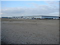
Sports World Head Office
Enormous warehouse and office complex with its own helipad. Mainly warehouse! I had to stand in the adjacent Grid Square in order to fit it all in.
Image: © Ian Paterson
Taken: 29 Aug 2007
0.07 miles
2
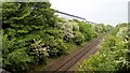
Robin Hood Railway line and Sports Direct
One of the lines closed in the days of rail rationalisation, but recently reopened and reinvigorated.
Sports Direct's vast warehouses are behind the trees.
Image: © Chris Morgan
Taken: 31 May 2016
0.13 miles
3
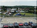
Chocks Away
Helicopter taking off from Sports World's head office helipad.
The registration code is G-CDWY, which was owned by Sportsdirect.com Retail Ltd at the time of the photo. The helicopter is an Agusta A109S.
For full history see https://siteapps.caa.co.uk/g-info/ where you will note that the registration code is G-DAYD and owned by Sky Border Logistics Ltd as at 6th November 2020.
Image: © Ian Paterson
Taken: 29 Aug 2007
0.15 miles
4
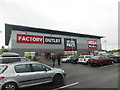
Factory Outlet
A discount warehouse, opposite the huge warehouse of Sports Direct
Image: © Graham Hogg
Taken: 31 May 2016
0.23 miles
5
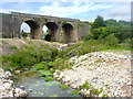
Railway bridge near works
A railway bridge in Shirebrook that passes over a bridleway and a stream.
Image: © James Hill
Taken: 4 Aug 2007
0.24 miles