IMAGES TAKEN NEAR TO
The Paddock, MANSFIELD, NG20 8QT
Introduction
This page details the photographs taken nearby to The Paddock, NG20 8QT by members of the Geograph project.
The Geograph project started in 2005 with the aim of publishing, organising and preserving representative images for every square kilometre of Great Britain, Ireland and the Isle of Man.

There are currently over 7.5m images from over14,400 individuals and you can help contribute to the project by visiting https://www.geograph.org.uk
Image Map
Images are licensed for reuse under creativecommons.org/licenses/by-sa/2.0
Notes
- Clicking on the map will re-center to the selected point.
- The higher the marker number, the further away the image location is from the centre of the postcode.
Image Listing (12 Images Found)
Images are licensed for reuse under creativecommons.org/licenses/by-sa/2.0
Image
Details
Distance
4
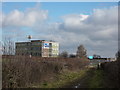
Shirebrook Academy
A college on Common Lane, Langwith Junction.
Image: © Peter Barr
Taken: 14 Feb 2011
0.19 miles
5
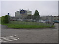
Shirebrook School
Positioned on top of a hill makes this multi-storey building ideal as a communication mast. Not sure if the signals interfere with the students in any way.
Image: © Michael Patterson
Taken: 26 May 2006
0.21 miles
7
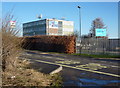
Shirebrook Academy across Common Lane
The main building seen from the start of the track west to Langwith Wood.
Image: © Andrew Hill
Taken: 8 Jan 2011
0.22 miles