IMAGES TAKEN NEAR TO
Carter Lane, MANSFIELD, NG20 8PW
Introduction
This page details the photographs taken nearby to Carter Lane, NG20 8PW by members of the Geograph project.
The Geograph project started in 2005 with the aim of publishing, organising and preserving representative images for every square kilometre of Great Britain, Ireland and the Isle of Man.

There are currently over 7.5m images from over14,400 individuals and you can help contribute to the project by visiting https://www.geograph.org.uk
Image Map
Images are licensed for reuse under creativecommons.org/licenses/by-sa/2.0
Notes
- Clicking on the map will re-center to the selected point.
- The higher the marker number, the further away the image location is from the centre of the postcode.
Image Listing (4 Images Found)
Images are licensed for reuse under creativecommons.org/licenses/by-sa/2.0
Image
Details
Distance
1

Shirebrook - The Old School Guest House on Main Street
Image: © Alan Heardman
Taken: 12 Oct 2008
0.15 miles
2
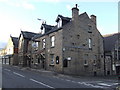
The Great Northern , Shirebrook
The only reminder that the Great Northern Railway had a presence in Shirebrook, adjacent to the pub.
Image: © al partington
Taken: 10 Dec 2007
0.17 miles
4
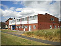
Row of shops off Hawthorne Avenue, Shirebrook
Accessed from a path leading to Elm Tree Avenue (behind the photographer). Only one shop actually remains, a fish and chip shop in the fourth unit from the camera; the other units have been converted for residential use, presumably in combination with what were the flats above the shops.
Image: © Richard Vince
Taken: 25 Jun 2022
0.25 miles