IMAGES TAKEN NEAR TO
Woodside Road, MANSFIELD, NG20 8LW
Introduction
This page details the photographs taken nearby to Woodside Road, NG20 8LW by members of the Geograph project.
The Geograph project started in 2005 with the aim of publishing, organising and preserving representative images for every square kilometre of Great Britain, Ireland and the Isle of Man.

There are currently over 7.5m images from over14,400 individuals and you can help contribute to the project by visiting https://www.geograph.org.uk
Image Map
Images are licensed for reuse under creativecommons.org/licenses/by-sa/2.0
Notes
- Clicking on the map will re-center to the selected point.
- The higher the marker number, the further away the image location is from the centre of the postcode.
Image Listing (5 Images Found)
Images are licensed for reuse under creativecommons.org/licenses/by-sa/2.0
Image
Details
Distance
1
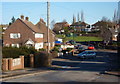
Looking along Recreation Road, Langwith Junction
The residential street curves and rises gently.
Image: © Andrew Hill
Taken: 8 Jan 2011
0.09 miles
2
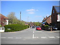
Station Road, Langwith Junction
Formerly leading to the railway station after which the village was named. The station, latterly renamed Shirebrook North, was built by the Lancashire, Derbyshire and East Coast Railway, and was the point at which a branch towards Sheffield left the "main line" to Chesterfield; there were also links to the Midland Railway's line from Mansfield to Worksop, which passes a little way to the east.
Image: © Richard Vince
Taken: 5 May 2018
0.21 miles
3
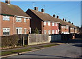
Houses on Recreation Road, Shirebrook
Traditional semis on this long residential street.
Image: © Andrew Hill
Taken: 8 Jan 2011
0.22 miles
4
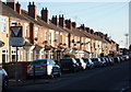
Terraced houses, Burlington Avenue
A long row of traditional terraced houses catching the winter mid-day sun.
Image: © Andrew Hill
Taken: 8 Jan 2011
0.22 miles
5
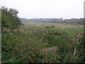
Former Shirebrook North
This is the site of the former Shirebrook North railway station. Before this name it was known as Langwith Junction due to the number of lines from different companies that passed through this point. The Robin Hood line running on the former Midland Railway lines is the only survivor.
Image: © Michael Patterson
Taken: 12 Sep 2006
0.24 miles