IMAGES TAKEN NEAR TO
Valley Road, MANSFIELD, NG20 8LQ
Introduction
This page details the photographs taken nearby to Valley Road, NG20 8LQ by members of the Geograph project.
The Geograph project started in 2005 with the aim of publishing, organising and preserving representative images for every square kilometre of Great Britain, Ireland and the Isle of Man.

There are currently over 7.5m images from over14,400 individuals and you can help contribute to the project by visiting https://www.geograph.org.uk
Image Map
Images are licensed for reuse under creativecommons.org/licenses/by-sa/2.0
Notes
- Clicking on the map will re-center to the selected point.
- The higher the marker number, the further away the image location is from the centre of the postcode.
Image Listing (8 Images Found)
Images are licensed for reuse under creativecommons.org/licenses/by-sa/2.0
Image
Details
Distance
1
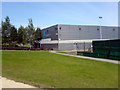
Leisure Centre, Shirebrook
A leisure centre in Shirebrook. Complete with skatepark, pond, fields and an enclosed football area.
Image: © James Hill
Taken: 23 Aug 2007
0.18 miles
2
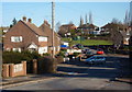
Looking along Recreation Road, Langwith Junction
The residential street curves and rises gently.
Image: © Andrew Hill
Taken: 8 Jan 2011
0.24 miles
4
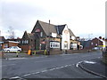
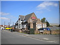
King of Diamonds, Langwith Junction
'Music' pub in the old railway town of Langwith Junction
Image: © al partington
Taken: 10 Dec 2007
0.24 miles
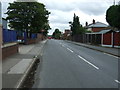
5
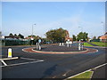
Shirebrook - Roundabout (Approaching Langwith Junction)
Image: © Alan Heardman
Taken: 12 Oct 2008
0.25 miles
6
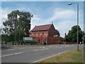
St Joseph's School in Shirebrook
Situated on Langwith Road.
Image: © Jonathan Clitheroe
Taken: 26 Jul 2014
0.25 miles
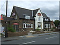
7
King of Diamonds, Langwith Road, Langwith Junction
Having been to see a band of my acquaintance here several years ago, I knew of this pub, but had never seen it in daylight before.
Image: © Richard Vince
Taken: 5 May 2018
0.25 miles
8
The King of Diamonds, Langwith Junction
On Langwith Road.
Image: © JThomas
Taken: 28 Aug 2014
0.25 miles