IMAGES TAKEN NEAR TO
Recreation Drive, MANSFIELD, NG20 8BX
Introduction
This page details the photographs taken nearby to Recreation Drive, NG20 8BX by members of the Geograph project.
The Geograph project started in 2005 with the aim of publishing, organising and preserving representative images for every square kilometre of Great Britain, Ireland and the Isle of Man.

There are currently over 7.5m images from over14,400 individuals and you can help contribute to the project by visiting https://www.geograph.org.uk
Image Map
Images are licensed for reuse under creativecommons.org/licenses/by-sa/2.0
Notes
- Clicking on the map will re-center to the selected point.
- The higher the marker number, the further away the image location is from the centre of the postcode.
Image Listing (10 Images Found)
Images are licensed for reuse under creativecommons.org/licenses/by-sa/2.0
Image
Details
Distance
1
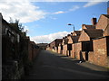
Back alley off Vale Drive, Shirebrook
Image: © Richard Vince
Taken: 14 Jun 2014
0.03 miles
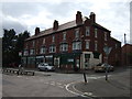
2
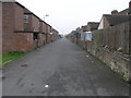
Back Lane
This lane is an access road for the rows of terraced houses which were built originally to house the miners and their families of the nearby colliery.
Image: © Michael Patterson
Taken: 12 Sep 2006
0.03 miles
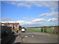
4
Field Drive, Shirebrook
Heading south east.
Image: © JThomas
Taken: 28 Aug 2014
0.09 miles
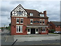
8

Offices by the Sports Direct warehouse complex
Image: © Chris Morgan
Taken: 31 May 2016
0.20 miles
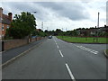
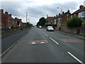
9

Wood Lane, Shirebrook
Looking north up Wood Lane in Shirebrook.
Image: © James Hill
Taken: 23 Aug 2007
0.20 miles
10
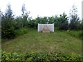
Shirebrook Colliery marker stone
Marking the site of Shirebrook Colliery which closed in 1993, just 3 years short of its centenary
Image: © Graham Hogg
Taken: 31 May 2016
0.22 miles