IMAGES TAKEN NEAR TO
Main Street, MANSFIELD, NG20 8AW
Introduction
This page details the photographs taken nearby to Main Street, NG20 8AW by members of the Geograph project.
The Geograph project started in 2005 with the aim of publishing, organising and preserving representative images for every square kilometre of Great Britain, Ireland and the Isle of Man.

There are currently over 7.5m images from over14,400 individuals and you can help contribute to the project by visiting https://www.geograph.org.uk
Image Map
Images are licensed for reuse under creativecommons.org/licenses/by-sa/2.0
Notes
- Clicking on the map will re-center to the selected point.
- The higher the marker number, the further away the image location is from the centre of the postcode.
Image Listing (24 Images Found)
Images are licensed for reuse under creativecommons.org/licenses/by-sa/2.0
Image
Details
Distance
1
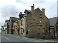
The Great Northern, Shirebrook
On King Edward Street (B6407).
Image: © JThomas
Taken: 28 Aug 2014
0.04 miles
2
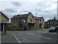
The Gate, Shirebrook
On King Edward Street (B6407).
Image: © JThomas
Taken: 28 Aug 2014
0.04 miles
3
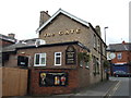
The Gate, Shirebrook
On King Edward Street (B6407).
Image: © JThomas
Taken: 28 Aug 2014
0.04 miles
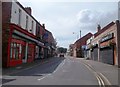
4
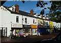
Victoria Street, Shirebrook
From the side of a car park. The street leads to the southwestern corner of the market square. The market town has a good selection of traditional style small shops and stores.
Image: © Andrew Hill
Taken: 12 Oct 2011
0.05 miles
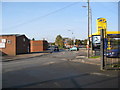
6
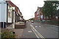
Main Street in Shirebrook
The B6407 road facing out of the town.
Image: © Jonathan Clitheroe
Taken: 26 Jul 2014
0.07 miles
10
Carter Lane, Shirebrook
Looking up Carter Lane, Workingmen's Club on left, Adult Education Centre on right.
Image: © Ann B
Taken: 31 May 2005
0.09 miles