IMAGES TAKEN NEAR TO
Bishops Meadows, MANSFIELD, NG20 0SQ
Introduction
This page details the photographs taken nearby to Bishops Meadows, NG20 0SQ by members of the Geograph project.
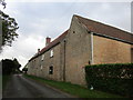
The Geograph project started in 2005 with the aim of publishing, organising and preserving representative images for every square kilometre of Great Britain, Ireland and the Isle of Man.

There are currently over 7.5m images from over14,400 individuals and you can help contribute to the project by visiting https://www.geograph.org.uk
Image Map
Images are licensed for reuse under creativecommons.org/licenses/by-sa/2.0
Notes
- Clicking on the map will re-center to the selected point.
- The higher the marker number, the further away the image location is from the centre of the postcode.
Image Listing (60 Images Found)
Images are licensed for reuse under creativecommons.org/licenses/by-sa/2.0
Image
Details
Distance
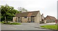
1
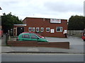
Church Warsop Memorial Club
On Bishops' Walk.
Image: © JThomas
Taken: 17 Mar 2014
0.06 miles
2
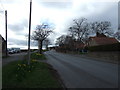
Bishops Walk, Church Warsop (B6031)
Heading west.
Image: © JThomas
Taken: 16 Mar 2014
0.07 miles
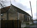
3
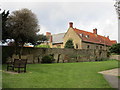
Parish Hall, Church Warsop, Notts.
The Parish Centre seen here from the B6031 (a.k.a. Bishop's Walk). This is a Grade II* listed building formerly known as Warsop Old Hall, with C14th, C15th, C16th and C18th elements. It was converted into a parish hall in 1972.
Image: © David Hallam-Jones
Taken: 23 Jan 2016
0.07 miles
4
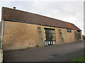
Warsop Parish Centre
A complex of buildings dating from the fourteenth century onwards https://historicengland.org.uk/listing/the-list/list-entry/1251896
Image: © Jonathan Thacker
Taken: 21 Sep 2018
0.08 miles
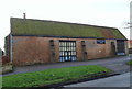
5
Warsop Parish Centre, the Tudor Barn
At Church Warsop
Image: © Chris Morgan
Taken: 31 May 2016
0.08 miles
7
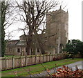
Parish Church, Church Warsop, Notts.
The northern elevation and western tower from a driveway off Bishop's Walk.
Image: © David Hallam-Jones
Taken: 23 Jan 2016
0.09 miles
9
Warsop Parish Centre
A complex of buildings dating from the fourteenth century onwards https://historicengland.org.uk/listing/the-list/list-entry/1251896
Image: © Jonathan Thacker
Taken: 21 Sep 2018
0.09 miles
10
Churchyard and Parish Centre, Warsop
The Parish Centre occupies a complex of buildings dating from the fourteenth century onwards https://historicengland.org.uk/listing/the-list/list-entry/1251896
Image: © Jonathan Thacker
Taken: 21 Sep 2018
0.10 miles