IMAGES TAKEN NEAR TO
Church Close, MANSFIELD, NG20 0SA
Introduction
This page details the photographs taken nearby to Church Close, NG20 0SA by members of the Geograph project.
The Geograph project started in 2005 with the aim of publishing, organising and preserving representative images for every square kilometre of Great Britain, Ireland and the Isle of Man.

There are currently over 7.5m images from over14,400 individuals and you can help contribute to the project by visiting https://www.geograph.org.uk
Image Map
Images are licensed for reuse under creativecommons.org/licenses/by-sa/2.0
Notes
- Clicking on the map will re-center to the selected point.
- The higher the marker number, the further away the image location is from the centre of the postcode.
Image Listing (79 Images Found)
Images are licensed for reuse under creativecommons.org/licenses/by-sa/2.0
Image
Details
Distance
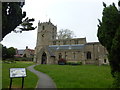
1
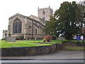
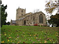
Parish Church, Church Warsop, Notts.
This view of the eastern end of the church, with a gate and steps up to the graveyard, is from Church Road.
Image: © David Hallam-Jones
Taken: 23 Jan 2016
0.06 miles
2
St Peter and St Paul's Church, Church Warsop
Image: © JThomas
Taken: 16 Mar 2014
0.08 miles
3
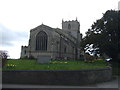
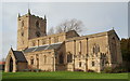
Parish Church, Church Warsop, Notts.
The northern elevation and western tower from a driveway off Bishop's Walk.
Image: © David Hallam-Jones
Taken: 23 Jan 2016
0.08 miles
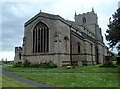
4
St Peter and St Paul parish church, Warsop
There was a church here at the time of the Domesday Book in 1086, although the building we see today incorporates work from many subsequent centuries.
Image: © Chris Morgan
Taken: 31 May 2016
0.08 miles
5
Church Warsop - Parish Church of St. Peter and St. Paul
Image: © Alan Heardman
Taken: 9 Nov 2008
0.08 miles
6
St Peter and St Paul's Church, Church Warsop
Image: © JThomas
Taken: 16 Mar 2014
0.08 miles
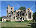
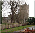
8
Parish Church, Church Warsop, Notts.
The Grade I-listed Parish church with sections and features dating from the C11th, C13th, C14th, C15th and C16th. It was, it seems, restored and re-roofed in 1878. The tower, on its west side, dates from the Cllth and C14th. It originally served a community of farmers but much later on its incumbents had to adapt their ministries to meet the needs of mining families from the 1930s onwards. From its perched position it looks out over The Carrs, a local nature reserve.
Image: © David Hallam-Jones
Taken: 23 Jan 2016
0.09 miles
9
St Peter and St Paul Church
The church from which the village takes its name
Image: © Graham Hogg
Taken: 31 May 2016
0.09 miles
10
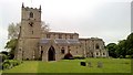
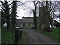
Parish Church, Warsop
View from the corner of the churchyard above the road to the north-east.
Image: © Andrew Hill
Taken: 15 May 2014
0.09 miles