IMAGES TAKEN NEAR TO
Hamilton Drive, MANSFIELD, NG20 0EY
Introduction
This page details the photographs taken nearby to Hamilton Drive, NG20 0EY by members of the Geograph project.
The Geograph project started in 2005 with the aim of publishing, organising and preserving representative images for every square kilometre of Great Britain, Ireland and the Isle of Man.

There are currently over 7.5m images from over14,400 individuals and you can help contribute to the project by visiting https://www.geograph.org.uk
Image Map
Images are licensed for reuse under creativecommons.org/licenses/by-sa/2.0
Notes
- Clicking on the map will re-center to the selected point.
- The higher the marker number, the further away the image location is from the centre of the postcode.
Image Listing (15 Images Found)
Images are licensed for reuse under creativecommons.org/licenses/by-sa/2.0
Image
Details
Distance
1
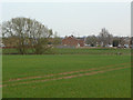
The end of Argyle Close
Modern housing development on the west of Market Warsop seen across the River Meden.
Image: © Alan Murray-Rust
Taken: 27 Mar 2011
0.08 miles
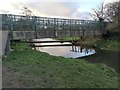
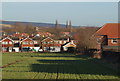
2
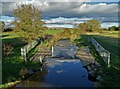
View from the bridge
The River Meden west of Market Warsop
Image: © Neil Theasby
Taken: 4 Nov 2021
0.11 miles
4
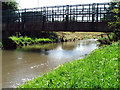
Another view of Stone Bridge
Stone Bridge in Warsop shot from the bank.
Image: © James Hill
Taken: 7 Jul 2007
0.12 miles
6
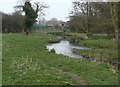
River Meden
Looking towards the site of the Stone Bridge. The bridge has this name on older maps and I have found reference to a destroyed pack horse bridge across the Meden which may well have been at this location.
Image: © Alan Murray-Rust
Taken: 27 Mar 2011
0.14 miles
7
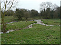
Braided stream
A relatively unusual feature in a lowland valley stream like this, but in fact the underlying rock strata are close to the surface, making for a shallow stream.
Image: © Alan Murray-Rust
Taken: 27 Mar 2011
0.16 miles
8
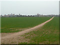
'Warsop FP3' footpath
Clearly a well beaten path paralleling the River Meden towards Warsop mill.
Image: © Alan Murray-Rust
Taken: 27 Mar 2011
0.17 miles
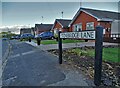
9
Stonebridge Lane, Market Warsop, Notts.
Houses on Stonebridge Lane seen from Sookholme Lane.
Image: © David Hallam-Jones
Taken: 28 Jan 2016
0.19 miles
10

Bridleway near Church Warsop
An old established route passing to the west of Market Warsop and Church Warsop.
Image: © Alan Murray-Rust
Taken: 27 Mar 2011
0.19 miles