IMAGES TAKEN NEAR TO
Clun Court, MANSFIELD, NG19 9RT
Introduction
This page details the photographs taken nearby to Clun Court, NG19 9RT by members of the Geograph project.
The Geograph project started in 2005 with the aim of publishing, organising and preserving representative images for every square kilometre of Great Britain, Ireland and the Isle of Man.

There are currently over 7.5m images from over14,400 individuals and you can help contribute to the project by visiting https://www.geograph.org.uk
Image Map
Images are licensed for reuse under creativecommons.org/licenses/by-sa/2.0
Notes
- Clicking on the map will re-center to the selected point.
- The higher the marker number, the further away the image location is from the centre of the postcode.
Image Listing (13 Images Found)
Images are licensed for reuse under creativecommons.org/licenses/by-sa/2.0
Image
Details
Distance
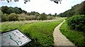
1
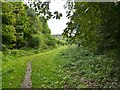
Footpath in an old quarry
In Maun Valley Park
Image: © Graham Hogg
Taken: 3 Oct 2017
0.10 miles
2
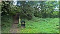
Way out from Maun Valley Country Park & Nature Reserve
Image: © Chris Morgan
Taken: 3 Oct 2017
0.10 miles
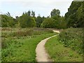
4
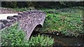
"The Dykes", Mansfield Woodhouse
This area, that I know as "The Dykes", runs alongside the River Maun. It looks more like a flood plain, although I personally have never seen it flooded.
Image: © James Hill
Taken: 4 Jun 2007
0.16 miles
6
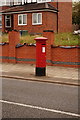
Edward VII postbox
On New Mill Lane, Mansfield Woodhouse.
Image: © Ian S
Taken: 8 Oct 2016
0.19 miles
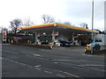
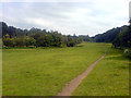
10
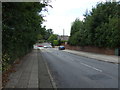
New Mill Lane, Mansfield Woodhouse
Heading west.
Image: © JThomas
Taken: 7 Sep 2013
0.22 miles