IMAGES TAKEN NEAR TO
Church Hill Avenue, MANSFIELD, NG19 9JU
Introduction
This page details the photographs taken nearby to Church Hill Avenue, NG19 9JU by members of the Geograph project.
The Geograph project started in 2005 with the aim of publishing, organising and preserving representative images for every square kilometre of Great Britain, Ireland and the Isle of Man.

There are currently over 7.5m images from over14,400 individuals and you can help contribute to the project by visiting https://www.geograph.org.uk
Image Map
Images are licensed for reuse under creativecommons.org/licenses/by-sa/2.0
Notes
- Clicking on the map will re-center to the selected point.
- The higher the marker number, the further away the image location is from the centre of the postcode.
Image Listing (36 Images Found)
Images are licensed for reuse under creativecommons.org/licenses/by-sa/2.0
Image
Details
Distance
1
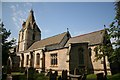
St.Edmund's church, Mansfield Woodhouse
The tower and short broach spire were rebuilt after a fire in 1304, the rest of the church is largely 1804-10, much restored by Sir G.G.Scott 1847-50.
Image: © Richard Croft
Taken: 11 Sep 2006
0.09 miles
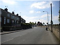
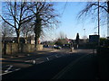
2
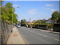
Church Hill, Mansfield Woodhouse
Looking towards the town centre.
Image: © Richard Vince
Taken: 5 May 2018
0.09 miles
3
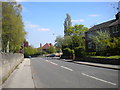
Mansfield Road, Mansfield Woodhouse (1)
Looking towards Mansfield Woodhouse town centre.
Image: © Richard Vince
Taken: 5 May 2018
0.11 miles
5
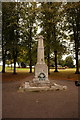
Mansfield Woodhouse War Memorial
Yeoman Hill Park.
Image: © Ian S
Taken: 8 Oct 2016
0.13 miles
6
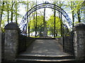
War memorial, Mansfield Woodhouse
In the north east corner of Yeoman's Hill Park.
Image: © Richard Vince
Taken: 5 May 2018
0.13 miles
7
Mansfield Road, Mansfield Woodhouse (2)
Looking towards Mansfield.
Image: © Richard Vince
Taken: 5 May 2018
0.13 miles
8
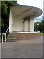
Mansfield Woodhouse Bandstand
Looking rather unloved, this bandstand is in the park across from St. Edmund's church. It is just on the border of SK5363 and SK5463, so much so that a shot taken from the front of the bandstand would put it in a different square to one from the side as here. At least it would appear to be so when using OS Explorer and Google Earth to obtain a grid reference.
Image: © James Hill
Taken: 26 Jun 2007
0.14 miles
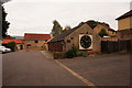
9
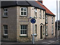
Mansfield Woodhouse - Turner Memorial Parish Room
On junction of Church Street and Welbeck Road.
Image: © Dave Bevis
Taken: 25 Feb 2009
0.14 miles
10
Mansfield Woodhouse - Approaching the mini-roundabout at the end of Priory Road
Image: © Alan Heardman
Taken: 10 Feb 2008
0.14 miles