IMAGES TAKEN NEAR TO
Wheatfield Crescent, MANSFIELD, NG19 9HQ
Introduction
This page details the photographs taken nearby to Wheatfield Crescent, NG19 9HQ by members of the Geograph project.
The Geograph project started in 2005 with the aim of publishing, organising and preserving representative images for every square kilometre of Great Britain, Ireland and the Isle of Man.

There are currently over 7.5m images from over14,400 individuals and you can help contribute to the project by visiting https://www.geograph.org.uk
Image Map
Images are licensed for reuse under creativecommons.org/licenses/by-sa/2.0
Notes
- Clicking on the map will re-center to the selected point.
- The higher the marker number, the further away the image location is from the centre of the postcode.
Image Listing (8 Images Found)
Images are licensed for reuse under creativecommons.org/licenses/by-sa/2.0
Image
Details
Distance
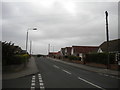
1
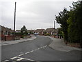
Marples Avenue, Mansfield Woodhouse (1)
From the junction with Dennor Drive.
Image: © Richard Vince
Taken: 15 Aug 2020
0.06 miles
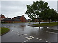
2
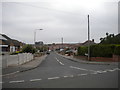
West end of Wheatfield Crescent, Mansfield Woodhouse
Off Marples Avenue.
Image: © Richard Vince
Taken: 15 Aug 2020
0.08 miles
3
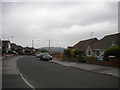
Marples Avenue, Mansfield Woodhouse (2)
From the junction with Dennor Drive.
Image: © Richard Vince
Taken: 15 Aug 2020
0.09 miles
4
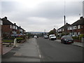
Marples Avenue, Mansfield Woodhouse (3)
From the junction with Wheatfield Crescent.
Image: © Richard Vince
Taken: 15 Aug 2020
0.11 miles
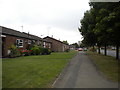
5
Dennor Drive, Mansfield Woodhouse
Off Peafield Lane.
Image: © Richard Vince
Taken: 15 Aug 2020
0.12 miles
7
Footpath alongside Litton Road, Mansfield Woodhouse
Image: © Richard Vince
Taken: 15 Aug 2020
0.22 miles
8
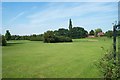
Mansfield Woodhouse Golf Course
View of the Golf Course taken from the car park at the side of the A60 road, Leeming Lane North.
Image: © Ann B
Taken: 7 Jun 2005
0.23 miles