IMAGES TAKEN NEAR TO
Peafield Lane, MANSFIELD, NG19 9EG
Introduction
This page details the photographs taken nearby to Peafield Lane, NG19 9EG by members of the Geograph project.
The Geograph project started in 2005 with the aim of publishing, organising and preserving representative images for every square kilometre of Great Britain, Ireland and the Isle of Man.

There are currently over 7.5m images from over14,400 individuals and you can help contribute to the project by visiting https://www.geograph.org.uk
Image Map
Images are licensed for reuse under creativecommons.org/licenses/by-sa/2.0
Notes
- Clicking on the map will re-center to the selected point.
- The higher the marker number, the further away the image location is from the centre of the postcode.
Image Listing (2 Images Found)
Images are licensed for reuse under creativecommons.org/licenses/by-sa/2.0
Image
Details
Distance
1
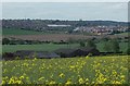
Peafield Farm and view to Mansfield
View near the start of the path by Peafield Plantation. Sandlands Way and the superstore can be seen.
Image: © Andrew Hill
Taken: 15 May 2014
0.21 miles
2
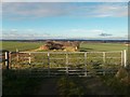
Track to Crimea Farm
Marked as a track on the map, this has obviously seen only foot traffic for a long time.
Image: © Antony Dixon
Taken: 4 Dec 2017
0.22 miles