IMAGES TAKEN NEAR TO
Studland Close, MANSFIELD, NG19 8UG
Introduction
This page details the photographs taken nearby to Studland Close, NG19 8UG by members of the Geograph project.
The Geograph project started in 2005 with the aim of publishing, organising and preserving representative images for every square kilometre of Great Britain, Ireland and the Isle of Man.

There are currently over 7.5m images from over14,400 individuals and you can help contribute to the project by visiting https://www.geograph.org.uk
Image Map
Images are licensed for reuse under creativecommons.org/licenses/by-sa/2.0
Notes
- Clicking on the map will re-center to the selected point.
- The higher the marker number, the further away the image location is from the centre of the postcode.
Image Listing (11 Images Found)
Images are licensed for reuse under creativecommons.org/licenses/by-sa/2.0
Image
Details
Distance
1
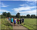
Mansfield parkrun
In Manor Park Sports Complex, Mansfield Woodhouse
Image: © Graham Hogg
Taken: 5 Aug 2017
0.02 miles
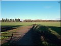
5
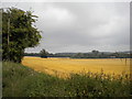
Fields north of Mansfield Woodhouse
Seen from Park Hall Road.
Image: © Richard Vince
Taken: 15 Aug 2020
0.20 miles
6
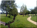
On the bridge looking north
Stood on one of the bridges on Manor Sports Complex, looking over the stream to the north.
Image: © James Hill
Taken: 19 May 2007
0.20 miles
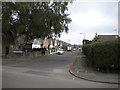
7
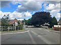
Park Hall Road in Mansfield Woodhouse
Pictured at its junction with Trafalgar Way. More new-builds are in evidence here at the northernmost edge of the town. The tree on the right of picture is a mature copper beech.
Image: © Jonathan Clitheroe
Taken: 30 Aug 2023
0.20 miles
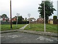
8
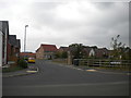
South end of Trafalgar Way, Mansfield Woodhouse
Leading to recent housing off Park Hall Road.
Image: © Richard Vince
Taken: 15 Aug 2020
0.22 miles
9
Farm Croft Road, Mansfield Woodhouse
Off Park Hall Road.
Image: © Richard Vince
Taken: 15 Aug 2020
0.23 miles
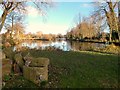
10
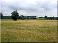
View over wheat field from Park Hall Road
In the distance, one can see the ponds that lay at the bottom of the nearby golf course.
Image: © James Hill
Taken: 16 Jun 2007
0.24 miles