IMAGES TAKEN NEAR TO
Northfield Lane, MANSFIELD, NG19 8SF
Introduction
This page details the photographs taken nearby to Northfield Lane, NG19 8SF by members of the Geograph project.
The Geograph project started in 2005 with the aim of publishing, organising and preserving representative images for every square kilometre of Great Britain, Ireland and the Isle of Man.

There are currently over 7.5m images from over14,400 individuals and you can help contribute to the project by visiting https://www.geograph.org.uk
Image Map
Images are licensed for reuse under creativecommons.org/licenses/by-sa/2.0
Notes
- Clicking on the map will re-center to the selected point.
- The higher the marker number, the further away the image location is from the centre of the postcode.
Image Listing (18 Images Found)
Images are licensed for reuse under creativecommons.org/licenses/by-sa/2.0
Image
Details
Distance
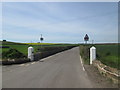
1
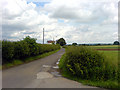
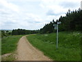
NE from Northfield Avenue
Looking north east from the top of Northfield Avenue.
Image: © James Hill
Taken: 16 Jun 2007
0.03 miles
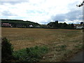
5
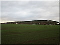
View towards Northfield Avenue
The restored former slag heap of Sherwood Colliery dominates in the distance.
Image: © Jonathan Thacker
Taken: 28 Nov 2017
0.11 miles
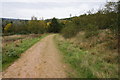
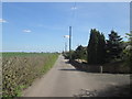
9
Footpath junction signpost
Near woodland to the west of Mansfield Woodhouse
Image: © Graham Hogg
Taken: 2 Jun 2014
0.23 miles
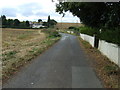
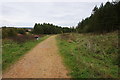
10
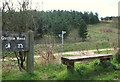
Mansfield Woodhouse Area NG19, Notts.
This footpath is part of one of the Mansfield Woodhouse Heritage Trails. Arrival here provides walkers who have come from either the mill ponds area of Pleasley Vale or Woodburn Lane, Pleasley Hill, with a choice of either turning right in order to reach Bull Farm (a suburb) in the vicinity of the A6191 (i.e. Chesterfield Road) or to the left, to reach the village of Mansfield Woodhouse. Oxclose Wood was landscaped on a colliery spoil site that was once part of Mansfield Woodhouse's Sherwood Colliery.
Image: © David Hallam-Jones
Taken: 28 Apr 2013
0.23 miles