IMAGES TAKEN NEAR TO
Pleasley Vale, MANSFIELD, NG19 8SB
Introduction
This page details the photographs taken nearby to NG19 8SB by members of the Geograph project.
The Geograph project started in 2005 with the aim of publishing, organising and preserving representative images for every square kilometre of Great Britain, Ireland and the Isle of Man.

There are currently over 7.5m images from over14,400 individuals and you can help contribute to the project by visiting https://www.geograph.org.uk
Image Map
Images are licensed for reuse under creativecommons.org/licenses/by-sa/2.0
Notes
- Clicking on the map will re-center to the selected point.
- The higher the marker number, the further away the image location is from the centre of the postcode.
Image Listing (69 Images Found)
Images are licensed for reuse under creativecommons.org/licenses/by-sa/2.0
Image
Details
Distance
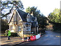
1
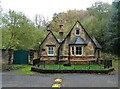
Pleasley Mills, Gardeners Lodge
This would have been part of the millowner's estate
Image: © Alan Murray-Rust
Taken: 22 Jun 2008
0.08 miles
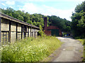
2
Industrial buildings, Pleasley Vale
By a footpath on the line of Forge Lane, north of the valley.
Image: © Andrew Hill
Taken: 1 Oct 2011
0.08 miles
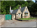
4
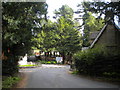
Coach House Lodge
A mid nineteenth century lodge https://www.britishlistedbuildings.co.uk/101108927-lodge-at-west-entrance-to-pleasley-vale-pleasley#.Wh84iDdpHVI
Image: © Jonathan Thacker
Taken: 28 Nov 2017
0.08 miles
5
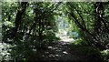
Forge Lane
The photograph is looking toward the southern end of Forge Lane and the beginning of a metalled surface just beyond the gate.
The metalled surface is one of two short sections of the lane that remain in this condition; the other section being near Image’s intersection with the B6407, the Pleasley to Shirebrook road.
Beyond the gate the lane passes some industrial units and then shares a junction with Outgang Lane in Pleasley Vale.
Although this is now a bridleway an OS map dated 1937-61 from the National Library of Scotland (https://maps.nls.uk/geo/explore/side-by-side/#zoom=16&lat=53.1818&lon=-1.2321&layers=10&right=osm) shows Forge Lane as being a single-track road between the B6407 and Pleasley Vale.
Image: © Alan Walker
Taken: 3 Jul 2018
0.09 miles
6
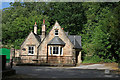
Gardeners Lodge
Named for one gardener or several? In the absence of an apostrophe we'll never know.
Image: © Graham Hogg
Taken: 2 Jun 2014
0.09 miles
7
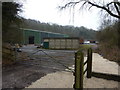
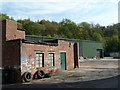
T.C.Fabrications; Pleasley Division
Industrial units on the edge of the wooded Pleasley Park; on the Archaeological Way path.
Image: © Peter Barr
Taken: 8 Jan 2013
0.09 miles
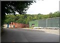
8
Buildings on Pleasley Vale land
Some buildings used for light industry on the Pleasley Vale Mills site.
Image: © James Hill
Taken: 16 Jun 2007
0.09 miles
9
Industrial Units in Pleasley Vale
These light engineering premises are located above the famous Pleasley Mills. The Archaeological Way passes through the site.
Image: © Jonathan Clitheroe
Taken: 26 Jul 2014
0.09 miles