IMAGES TAKEN NEAR TO
Sookholme, MANSFIELD, NG19 8LP
Introduction
This page details the photographs taken nearby to NG19 8LP by members of the Geograph project.
The Geograph project started in 2005 with the aim of publishing, organising and preserving representative images for every square kilometre of Great Britain, Ireland and the Isle of Man.

There are currently over 7.5m images from over14,400 individuals and you can help contribute to the project by visiting https://www.geograph.org.uk
Image Map
Images are licensed for reuse under creativecommons.org/licenses/by-sa/2.0
Notes
- Clicking on the map will re-center to the selected point.
- The higher the marker number, the further away the image location is from the centre of the postcode.
Image Listing (32 Images Found)
Images are licensed for reuse under creativecommons.org/licenses/by-sa/2.0
Image
Details
Distance
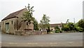
2
Sookholme, Notts.
This photograph is from the start (or exit) of Bath Lane, a rural lane that'becomes' Wood Lane beyond Sookholme Bath. Ahead, and on the other side of Sookholme Road, is Spring Farm is seen, part of which appears to have been converted into non-agriculturally related residential accommodation. Sookholme Bath, it seems, may well have been the site of a former Roman tile manufacturing site.
Image: © David Hallam-Jones
Taken: 28 Jan 2016
0.02 miles
3
Sookholme, Notts.
With 99.9% of the half-mile long Longster Lane behind the photographer, the B6407 is known as Sookholme Road once round this bend. This is a corner of Spring Farm on the left and ahead, between the lamp post and the yellow-border chevron sign, is the start (or termination) of Bath Lane, an unsurfaced rural lane that runs parallel with the southern boundary of Shirebrook Woods. The Shirebrook Woods country park has been created on the site of the former Shirebrook Colliery. Bath Lane is the location of Sookhole Bath - a shallow pool reported to have provided healing for people with rheumatism - and also off the lane, is the site of a former Roman tile kiln.
Image: © David Hallam-Jones
Taken: 28 Jan 2016
0.03 miles
4
Bath Lane, Sookholme, Notts.
A view from Longster Lane (B6407) of the access/exit point to Bath Lane. Spring Farm is immediately behind the photographer, on the opposite side of this road. It seems that Bath Lane was so named because of a pool 500 metres further up it that was fed by a spring whose waters were associated with the healing of rheumatism.
Image: © David Hallam-Jones
Taken: 28 Jan 2016
0.04 miles
5
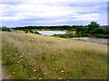
Overlooking the ponds
Two of the ponds on reclaimed land near Sookholme.
Image: © James Hill
Taken: 4 Aug 2007
0.09 miles
6
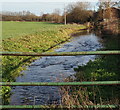
Hall Farm, Sookholme, Notts.
A river running towards the southern edge of Sookholme Moor is seen here behind Hall Farm.
Image: © David Hallam-Jones
Taken: 28 Jan 2016
0.09 miles
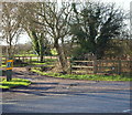
7
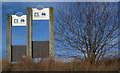
Shirebrook Woods, Longster Lane, Sookholme, Notts.
A public car park, off Longster Lane (the B6407), can be found on the other side of these park-name signs. Behind the photographer lies the largest of the five artificially created lakes on this reclaimed pit site. The park's predecessor, Shirebrook Colliery, functioned between 1896-1993.
Image: © David Hallam-Jones
Taken: 28 Jan 2016
0.11 miles
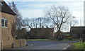
9
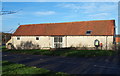
Hall Farm Barn, Sookholme, Notts.
The addition of the large windows to the rear elevation of this early and mid C19th, Grade II-listed, barn provides the owners of what is now a residential property with this view of Sookholme Road.
Image: © David Hallam-Jones
Taken: 28 Jan 2016
0.14 miles
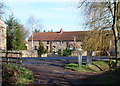
10
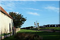
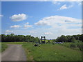
Hall Farm, Sookholme, Notts.
This view from the rear of the barn of Hall Farm provides glimpses of Sookholme Road (the B6407) curving right and Sookholme Lane sloping upwards on the left. This Grade II-listed barn, that has been converted into residential accommodation, dates from the early and mid C19th. St Augustine’s Church is situated 150 yds along Sookholme Lane.
Image: © David Hallam-Jones
Taken: 28 Jan 2016
0.14 miles