IMAGES TAKEN NEAR TO
Sookholme Road, MANSFIELD, NG19 8GA
Introduction
This page details the photographs taken nearby to Sookholme Road, NG19 8GA by members of the Geograph project.
The Geograph project started in 2005 with the aim of publishing, organising and preserving representative images for every square kilometre of Great Britain, Ireland and the Isle of Man.

There are currently over 7.5m images from over14,400 individuals and you can help contribute to the project by visiting https://www.geograph.org.uk
Image Map
Images are licensed for reuse under creativecommons.org/licenses/by-sa/2.0
Notes
- Clicking on the map will re-center to the selected point.
- The higher the marker number, the further away the image location is from the centre of the postcode.
Image Listing (31 Images Found)
Images are licensed for reuse under creativecommons.org/licenses/by-sa/2.0
Image
Details
Distance
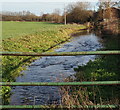
1
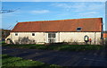
Hall Farm Barn, Sookholme, Notts.
The addition of the large windows to the rear elevation of this early and mid C19th, Grade II-listed, barn provides the owners of what is now a residential property with this view of Sookholme Road.
Image: © David Hallam-Jones
Taken: 28 Jan 2016
0.01 miles
2
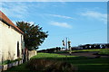
Hall Farm, Sookholme, Notts.
This view from the rear of the barn of Hall Farm provides glimpses of Sookholme Road (the B6407) curving right and Sookholme Lane sloping upwards on the left. This Grade II-listed barn, that has been converted into residential accommodation, dates from the early and mid C19th. St Augustine’s Church is situated 150 yds along Sookholme Lane.
Image: © David Hallam-Jones
Taken: 28 Jan 2016
0.01 miles
3
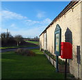
Sookholme, Notts.
The rear (Sookholme Road-facing) elevation of the barn of Hall Farm provides a site for the hamlet's post box and community noticeboard. Since there is currently an immense amount of strong 'local' feeling against a proposal to create a solar energy farm in a field off Sookholme Road, near to a number of 'listed' buildings - including this one and St Augustine's Church - the noticeboard was dominated by posters protesting about this proposal.
Image: © David Hallam-Jones
Taken: 28 Jan 2016
0.01 miles
4
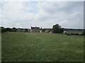
Grass field between St. Augustine's church and Hall Farm, Sookholme
Image: © Jonathan Thacker
Taken: 9 Sep 2021
0.03 miles
5
Hall Farm, Sookholme, Notts.
A river running towards the southern edge of Sookholme Moor is seen here behind Hall Farm.
Image: © David Hallam-Jones
Taken: 28 Jan 2016
0.05 miles
6
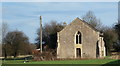
Sookholme Church, Sookholme, Notts.
The western elevation of the Grade I-listed St Augustine's Church, Sookholme Lane showing the church door.
Image: © David Hallam-Jones
Taken: 28 Jan 2016
0.08 miles
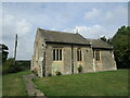
7

Sookholme, Notts.
The western end of St Augustine's Church with the rooftops of neighbouring residential and farm buildings. These other buildings are situated on Longster Lane and Sookholme Road, i.e. the B6407.
Image: © David Hallam-Jones
Taken: 28 Jan 2016
0.08 miles
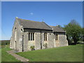
9
St. Augustine's church, Sookholme
A Norman chapel though the windows are all much later https://historicengland.org.uk/listing/the-list/list-entry/1262532
Image: © Jonathan Thacker
Taken: 9 Sep 2021
0.09 miles
10

St Augustine, Sookholm
From Southwell and Nottingham Church History website;
"A tiny, aisleless, Norman chapel, one of the smallest churches in the county, with a simple chancel arch of about 1100 and three east windows of similar date.
Although the west wall was rebuilt in the 19th century, much of the rest of the building is Norman and later medieval. Inside are two early roof beams and an interesting sedile (seat) on the south wall with a coat of arms."
And there's more here;
And there's more here; http://www.nottshistory.org.uk/mansfieldchurches/sookholme.htm
Image: © Chris Morgan
Taken: 31 May 2016
0.09 miles