IMAGES TAKEN NEAR TO
Chesterfield Road North, MANSFIELD, NG19 7SR
Introduction
This page details the photographs taken nearby to Chesterfield Road North, NG19 7SR by members of the Geograph project.
The Geograph project started in 2005 with the aim of publishing, organising and preserving representative images for every square kilometre of Great Britain, Ireland and the Isle of Man.

There are currently over 7.5m images from over14,400 individuals and you can help contribute to the project by visiting https://www.geograph.org.uk
Image Map
Images are licensed for reuse under creativecommons.org/licenses/by-sa/2.0
Notes
- Clicking on the map will re-center to the selected point.
- The higher the marker number, the further away the image location is from the centre of the postcode.
Image Listing (90 Images Found)
Images are licensed for reuse under creativecommons.org/licenses/by-sa/2.0
Image
Details
Distance
1
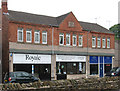
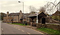
Pleasley - Beehive Buildings
On Meden Square. The date-stone shows 1895. For a 1950 photo of these shops, please see http://www.picturethepast.org.uk/frontend.php?keywords=Ref_No_increment;EQUALS;NCCW001655&pos=1&action=zoom&id=50634 .
Image: © Dave Bevis
Taken: 20 May 2013
0.01 miles
2
Beehive Buildings, 1899, Pleasley
The name confirms the first impression that this might have been a C0-operative store, the beehive being one of the symbols of the movement. The date stone in the pediment carries the date 1899.
Image: © Alan Murray-Rust
Taken: 5 Dec 2014
0.01 miles
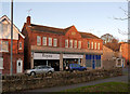
3
Meden Square
The commercial centre of Pleasley, although not technically in the parish of Pleasley as it lies on the Nottinghamshire side of the River Meden. A couple of coal tubs stand in the square as a reminder of the reason behind the main occupation of the village for around 100 years.
Image: © Alan Murray-Rust
Taken: 31 Jan 2010
0.01 miles
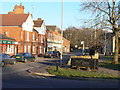
4
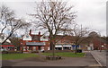
Pleasley NG19, Near Mansfield, Notts.
Behind the photographer is the A619 (Chesterfield Road North) that connects Mansfield-Chesterfield. Chesterfield Road, the former trunk road, is seen here passing the lych-gate style bus shelter. Crow Hill is the road branching off on the left. This village green area is known as Meden Square, presumably taking its name from the River Meden. Meden Mill, the former water-powered C17th corn mill that has been reconstructed as private residence is the building roofed with the red pantiles beyond the bus shelter.
Image: © David Hallam-Jones
Taken: 28 Apr 2013
0.02 miles
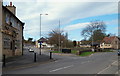
5
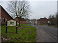
Welcome to Pleasley
Pub and shops ahead at the A 619 and onto a minor road.
Image: © Peter Barr
Taken: 8 Jan 2013
0.02 miles
6
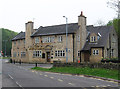
Pleasley - The White Swan
On Meden Square. For an alternative view, please see Peter Barr's Image
Image: © Dave Bevis
Taken: 20 May 2013
0.02 miles
7
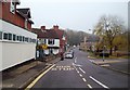
Pleasley NG19, Near Mansfield, Notts.
A set of traffic lights in the distance - beyond The White Swan - mark the point where buses travelling towards Chesterfield from the Mansfield direction via the A617 dual-carriageway ("Chesterfield Road North") turn off into this the lower end of Pleasley. This area of Pleasley is known as Meden Square.
Image: © David Hallam-Jones
Taken: 28 Apr 2013
0.02 miles
8
The Centre of Pleasley
Meden Square in the centre of Pleasley. The busy A617 road rumbles away at the far end of this main thoroughfare.
Image: © Jonathan Clitheroe
Taken: 11 Nov 2011
0.03 miles
9
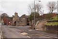
Pleasley NG19, Near Mansfield, Notts
Meden Square is actually triangular in shape. This lych-gate style bus shelter on the "old" Chesterfield Road also serves "park" users. The nearby A617 dual carriageway now carries most of the traffic between Mansfield-Chesterfield. The pink fronted shop is the former post office, now an "antiques and collectibles" shop.
Image: © David Hallam-Jones
Taken: 28 Apr 2013
0.03 miles
10
Pleasley NG19, Near Mansfield, Notts
The White Swan has its main entrances on Chesterfield Road. This however, is the view from one side of Meden Square. The stairs and a steep path on the right ascend Meden Bank, formerly Gas Hill.
Image: © David Hallam-Jones
Taken: 28 Apr 2013
0.03 miles