IMAGES TAKEN NEAR TO
Batley Lane, MANSFIELD, NG19 7QL
Introduction
This page details the photographs taken nearby to Batley Lane, NG19 7QL by members of the Geograph project.
The Geograph project started in 2005 with the aim of publishing, organising and preserving representative images for every square kilometre of Great Britain, Ireland and the Isle of Man.

There are currently over 7.5m images from over14,400 individuals and you can help contribute to the project by visiting https://www.geograph.org.uk
Image Map
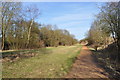
Images are licensed for reuse under creativecommons.org/licenses/by-sa/2.0
Notes
- Clicking on the map will re-center to the selected point.
- The higher the marker number, the further away the image location is from the centre of the postcode.
Image Listing (32 Images Found)
Images are licensed for reuse under creativecommons.org/licenses/by-sa/2.0
Image
Details
Distance
1
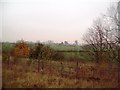
Batley Farm Viewed from Longhedge Lane
Looking towards the farm from a path in Pleasley Country Park on a bleak Friday in mid November.
Image: © Jonathan Clitheroe
Taken: 11 Nov 2011
0.01 miles
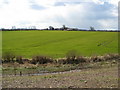
2
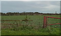
Field near Batley Farm
View from Batley Lane, with the chimney at Pleasley in the right distance.
Image: © Andrew Hill
Taken: 1 Dec 2011
0.05 miles
5
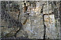
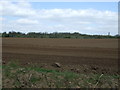
Lower Magnesian Limestone
A view of the exposed LML, a dolomite rich limestone formed in the Permian (Zechstein sea). It is heavily fractured and fissured, a slight normal fault can be seen to the right.
Image: © Ashley Dace
Taken: 24 Feb 2011
0.14 miles
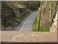
6
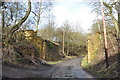
Former Railway Bridge
The deck has been removed from this one, and this is good preservation for this stretch of line, the others are now a pile of overgrown bricks.
Left to a car park near Ault Hucknall and right for Pleasley.
Image]
Image: © Ashley Dace
Taken: 24 Feb 2011
0.14 miles
7
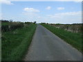
Pleasley Pit Country Park - Footpath View
Looking in the direction of Batley Farm.
Image: © Alan Heardman
Taken: 6 Apr 2008
0.15 miles
8
Railway Cutting
The wide cutting went through the local lower magnesian limestone, gently dipping to the north east.
Image]
Image: © Ashley Dace
Taken: 24 Feb 2011
0.15 miles
9
Former Railway Junction
The line to Teversal running behind me with the line to Bolsover and beyond would have run to the left of me.
This photo was taken from the right edge of this Image] railway bridge (closest).
Image: © Ashley Dace
Taken: 24 Feb 2011
0.16 miles
10
Batley Lane rail bridges
Two former colliery branch lines converged here, near Pleasley Colliery.
Image: © Peter Barr
Taken: 25 Mar 2011
0.16 miles