IMAGES TAKEN NEAR TO
Chesterfield Road North, MANSFIELD, NG19 7PA
Introduction
This page details the photographs taken nearby to Chesterfield Road North, NG19 7PA by members of the Geograph project.
The Geograph project started in 2005 with the aim of publishing, organising and preserving representative images for every square kilometre of Great Britain, Ireland and the Isle of Man.

There are currently over 7.5m images from over14,400 individuals and you can help contribute to the project by visiting https://www.geograph.org.uk
Image Map
Images are licensed for reuse under creativecommons.org/licenses/by-sa/2.0
Notes
- Clicking on the map will re-center to the selected point.
- The higher the marker number, the further away the image location is from the centre of the postcode.
Image Listing (95 Images Found)
Images are licensed for reuse under creativecommons.org/licenses/by-sa/2.0
Image
Details
Distance
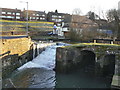
1
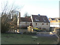
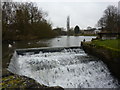
Meden Mill, Pleasley
The mill itself is now converted to business premises. In front of it the mill dam with sluices and slipway is Listed grade II.
Image: © Alan Murray-Rust
Taken: 31 Jan 2010
0.01 miles
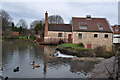
2
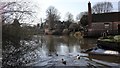
Pleasley Mill Pond
This photograph is looking across the northern end of the Mill Pond. The pond was used to drive Pleasley Mill, part of which can be seen on the right of the photograph. This mill was a flour mill unlike the mills in Pleasley Vale which produced textiles.
***
See also these photographs by
Peter Barr:- Image and
Alan Murray-Rust:- Image
Image: © Alan Walker
Taken: 28 Mar 2019
0.02 miles
3
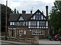
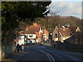
Nag's Head in Pleasley
Situated on Chesterfield Road south east of Newboundmill Lane. The pub is half timdered and possibly dates from the 1920s.
Image: © Bobby Clegg
Taken: 27 Aug 2015
0.03 miles
4
Pleasley - Nags Head
For an alternative view, please see Alan Murray-Rust's Image
Image: © Dave Bevis
Taken: 20 May 2013
0.03 miles
5
Pleasley Mill and pond
A high level view from Meden Bank.
Image: © Alan Murray-Rust
Taken: 31 Jan 2010
0.04 miles
6
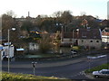
Chesterfield Road
The old main road through Pleasley, looking down into what is now the centre of the village. Strictly speaking the parish of Pleasley stops at the River Meden which passes under the road just in front of the prominent white house. The far side of the river is the Nottinghamshire parish of Pleasleyhill, which formed the larger part of the community by the end of the 19th century.
Image: © Alan Murray-Rust
Taken: 31 Jan 2010
0.04 miles
7
Bird-life on Pleasley Mill Pond
The slipway can also be seen at Image
Image: © Peter Barr
Taken: 8 Jan 2013
0.04 miles
8
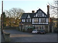
Nags Head
Large half-timbered style pub in Pleasley.
Image: © Alan Murray-Rust
Taken: 31 Jan 2010
0.04 miles
9
Meden Mill
The 18th century watermill was demolished in the 1950s but the steam mill survives. A steam mill was required as two mills further upstream often took too much water. The sluices and gates are grade II listed.
See also Image]
Image: © Ashley Dace
Taken: 24 Feb 2011
0.04 miles
10
Pleasley Mill Dam
Late 18th century structure including sluices and a slipway, on the River Meden. Listed grade II.
Image: © Alan Murray-Rust
Taken: 31 Jan 2010
0.04 miles