IMAGES TAKEN NEAR TO
Helmsdale Close, MANSFIELD, NG19 6RF
Introduction
This page details the photographs taken nearby to Helmsdale Close, NG19 6RF by members of the Geograph project.
The Geograph project started in 2005 with the aim of publishing, organising and preserving representative images for every square kilometre of Great Britain, Ireland and the Isle of Man.

There are currently over 7.5m images from over14,400 individuals and you can help contribute to the project by visiting https://www.geograph.org.uk
Image Map
Images are licensed for reuse under creativecommons.org/licenses/by-sa/2.0
Notes
- Clicking on the map will re-center to the selected point.
- The higher the marker number, the further away the image location is from the centre of the postcode.
Image Listing (8 Images Found)
Images are licensed for reuse under creativecommons.org/licenses/by-sa/2.0
Image
Details
Distance
1
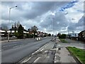
A38 Road in Mansfield
Arterial route into the town from the west.
Image: © Jonathan Clitheroe
Taken: 13 Apr 2022
0.08 miles
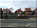
4
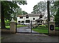
Grand house on King's Lodge Lane, Mansfield
Image: © Neil Theasby
Taken: 20 Jul 2019
0.20 miles
5
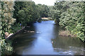
River Maun at Kings Mill
Looking east from the old viaduct. The area on the left is now a nature reserve.
Image: © Alan Murray-Rust
Taken: 22 Jun 2008
0.23 miles
6
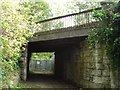
Railway Bridge Behind Hermitage Mill
This surprisingly fancy little bridge carries the Robin Hood Line over a track which used to be the back entrance to Hermitage Mill.
Image: © Antony Dixon
Taken: 23 Sep 2011
0.23 miles
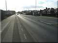
7
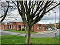
Kingsmill Ambulance Station in Mansfield
Part of the hospital infrastructure.
Image: © Jonathan Clitheroe
Taken: 13 Apr 2022
0.23 miles
8
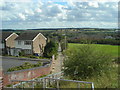
Footpath from Skegby Lane to Sutton Road, Mansfield
Grange Farm Estate on the left, former farmland on the right, new accommodation blocks at King's Mill Hospital right of centre, Hamilton Hill in the distance and Cox Moor on the horizon.
Image: © Antony Dixon
Taken: 13 Sep 2011
0.25 miles