IMAGES TAKEN NEAR TO
Langford Road, MANSFIELD, NG19 6QA
Introduction
This page details the photographs taken nearby to Langford Road, NG19 6QA by members of the Geograph project.
The Geograph project started in 2005 with the aim of publishing, organising and preserving representative images for every square kilometre of Great Britain, Ireland and the Isle of Man.

There are currently over 7.5m images from over14,400 individuals and you can help contribute to the project by visiting https://www.geograph.org.uk
Image Map
Images are licensed for reuse under creativecommons.org/licenses/by-sa/2.0
Notes
- Clicking on the map will re-center to the selected point.
- The higher the marker number, the further away the image location is from the centre of the postcode.
Image Listing (6 Images Found)
Images are licensed for reuse under creativecommons.org/licenses/by-sa/2.0
Image
Details
Distance
1
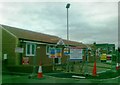
James Chapman Homes, development, Mansfield
Image: © Alex McGregor
Taken: 15 Feb 2012
0.15 miles
2
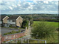
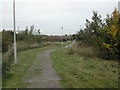
Footpath from Skegby Lane to Sutton Road, Mansfield
Grange Farm Estate on the left, former farmland on the right, new accommodation blocks at King's Mill Hospital right of centre, Hamilton Hill in the distance and Cox Moor on the horizon.
Image: © Antony Dixon
Taken: 13 Sep 2011
0.20 miles
5
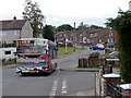
Housing Estate Footpath
running along the side of the estate in south west Mansfield
Image: © Tom Courtney
Taken: 9 Oct 2005
0.23 miles
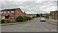
6
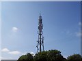
Mansfield Transmitter
Mansfield's Transmitter that broadcasts Mansfield 103.2 Radio.
Image: © Jack
Taken: 25 Aug 2007
0.23 miles