IMAGES TAKEN NEAR TO
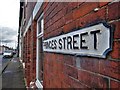
Princes Street, MANSFIELD, NG18 5SN
Introduction
This page details the photographs taken nearby to Princes Street, NG18 5SN by members of the Geograph project.
The Geograph project started in 2005 with the aim of publishing, organising and preserving representative images for every square kilometre of Great Britain, Ireland and the Isle of Man.

There are currently over 7.5m images from over14,400 individuals and you can help contribute to the project by visiting https://www.geograph.org.uk
Image Map
Images are licensed for reuse under creativecommons.org/licenses/by-sa/2.0
Notes
- Clicking on the map will re-center to the selected point.
- The higher the marker number, the further away the image location is from the centre of the postcode.
Image Listing (23 Images Found)
Images are licensed for reuse under creativecommons.org/licenses/by-sa/2.0
Image
Details
Distance
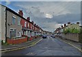
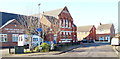
2
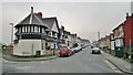
Corner of Tenter Street and Princess Street, Mansfield
This corner house must have a story to tell.
Image: © Chris Morgan
Taken: 31 Mar 2014
0.10 miles
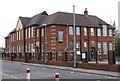
3
Mansfield - Primitive Methodist Centenary Hall
On Victoria Street.
Image: © Dave Bevis
Taken: 14 Apr 2011
0.11 miles
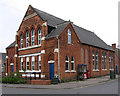
5
Victoria Street, Mansfield, Notts.
The Salvation Army Church Centre situated on the side of a T junction formed by Victoria St (i.e. behind the photographer and ahead too) with Tenter Street branching off to the left. As well as home to traditional facilities, i.e its Citadel and hall, it is also an accredited Contact Centre where estranged parents can have supervised periodic contact with a parent.
Image: © David Hallam-Jones
Taken: 20 Jan 2016
0.12 miles
6

Sutton Road, Mansfield, Notts.
The Stagecoach bus depot occupies a substantial plot on one side of Sutton Road (the A38) obliquely opposite Mansfield Community Hospital. This is a view looking towards Mansfield Road and Kings Mill Hospital, with the town centre behind the photographer. Today, the comprehensive network of commercial bus routes radiating outwards from the town is mainly provided by Stagecoach in Mansfield and Trent Barton buses, although one or two smaller companies (presumably not serviced here) also contribute.
Image: © David Hallam-Jones
Taken: 16 Jun 2013
0.17 miles
7
Mansfield - Sutton Road Primary School
On Moor Lane.
Image: © Dave Bevis
Taken: 14 Apr 2011
0.18 miles

9

Community Hospital, Mansfield, Notts.
The pedestrian entrance to the Community Hospital site, off Stockwell Gate (the A38). Four hospitals, i.e. King's Mill, Newark General, Ashfield Community Hospital and this one are all part of the Sherwood Forest NHS Foundation Trust. Mansfield's Workhouse was previously located on this site. It closed in 1930 and its buildings were demolished in 2003.
Image: © David Hallam-Jones
Taken: 16 Jun 2013
0.19 miles
10

The Bold Forester pub, Mansfield
On Sutton Road.
Image: © JThomas
Taken: 16 Mar 2014
0.20 miles