IMAGES TAKEN NEAR TO
Cinder Lane, NG18 5FS
Introduction
This page details the photographs taken nearby to Cinder Lane, NG18 5FS by members of the Geograph project.
The Geograph project started in 2005 with the aim of publishing, organising and preserving representative images for every square kilometre of Great Britain, Ireland and the Isle of Man.

There are currently over 7.5m images from over14,400 individuals and you can help contribute to the project by visiting https://www.geograph.org.uk
Image Map
Images are licensed for reuse under creativecommons.org/licenses/by-sa/2.0
Notes
- Clicking on the map will re-center to the selected point.
- The higher the marker number, the further away the image location is from the centre of the postcode.
Image Listing (18 Images Found)
Images are licensed for reuse under creativecommons.org/licenses/by-sa/2.0
Image
Details
Distance
1
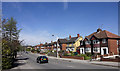
Sheepbridge Lane
On the outskirts of Mansfield. Named after the old sheep bridge which crosses the road at SK 528600.
Image: © Andy Stephenson
Taken: 17 Apr 2005
0.04 miles
3
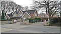
Paddock Close
Large, modern housing to the south west of the town centre.
Image: © Graham Hogg
Taken: 31 Mar 2014
0.12 miles
4
Bleak Hills Area, Mansfield, Notts.
Bleak Hills Lane seen from the point where Sheepbridge Lane and High Oakham Hill become one. Locals, who were younger in the 1940s, describe knowing Bleak Hills Lane as a cinder track that was also known as Harvey's Lane. It leads past Bleak Hill Dam (a former mill pond, now a private fishing location) as far as the site of a former cottage called Beeton's Cottage that is hosts a large house called Bleak Hills House. A 'footpath only' continues beyond this replacement house to Hamilton Way on the edge of the Bleak Hills Industrial Zone.
Image: © David Hallam-Jones
Taken: 16 Jun 2013
0.13 miles
5
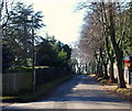
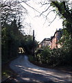
Atkin Lane, Mansfield, Notts.
With the main Mansfield-Nottingham road (the A60) 5 minutes walk away - behind the photographer - this is a view along Atkin Lane towards its continuous link with High Oakham Hill (< road name). High Oakham Drive is the turning on the left by the fence.
Image: © David Hallam-Jones
Taken: 8 Feb 2015
0.14 miles
6
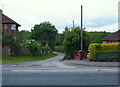
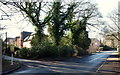
Cherry Lane, Mansfield, Notts.
The High Oakham Road/Atkin Lane Junction lies immediately beyond the road sign that is visible at the other end of this un-made (and perhaps unadopted?) road.
Image: © David Hallam-Jones
Taken: 8 Feb 2015
0.15 miles
7
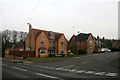
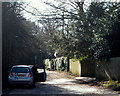
Cherry Lane, Mansfield, Notts.
This unmade (and perhaps unadopted?) road links Atkin Lane - behind the photographer - with High Oakham Road ahead - beyond the parked car.
Image: © David Hallam-Jones
Taken: 8 Feb 2015
0.15 miles
8
Atkin Lane/High Oakham Drive Junction, Mansfield, Notts.
High Oakham Drive is seen here branching off Atkin Lane. Within several hundred metres - behind the photographer - Atkin Lane joins the main Nottingham-Mansfield Road (the A60).
Image: © David Hallam-Jones
Taken: 8 Feb 2015
0.15 miles
9
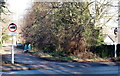
High Oakham Drive, Mansfield, Notts.
The lower, open end of this cul-de-sac is seen from its junction with Atkin Lane. A street name sign describing it's status as a "private road" (perhaps unadopted?) is situated nearby.
Image: © David Hallam-Jones
Taken: 8 Feb 2015
0.15 miles
10
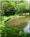
Bleak Hills Area, Mansfield, Notts.
Cauldwell Brook empties into Bleak Hills Dam south of Mansfield and some of the water flows on northwards to join the River Maun. This is a picture of northern-most lake called Mill Pond (previously an industrial mill pond) seen from approximately one third of the way down Bleak Hills Lane on the right-hand side off Sheepbridge Lane. Some locals I spoke to, who were of course much younger in the 1940s, describe knowing Bleak Hills Lane as a cinder track that was also known as Harvey's Lane. This road (track) leads past Bleak Hills Dam (now a private fishing location) up as far as the site of a former cottage called Beeton's Cottage which is now known as Bleak Hills House. A footpath continues beyond this larger (replacement) house to Hamilton Way on the edge of the Bleak Hills Industrial Zone. A notice near this pond refers to it as the Bleak Hills Fishery and Bird Sanctuary’s "Railway site". Apparently a stretch of the railway line between Mansfield to Kirkby South Junction from Reeds Mill once passed through this area. It seems that when the line was laid, in order to create a straight route towards Sheepbridge Lane and Garth Road (both of which lie behind the photographer), the easiest remedy was to create an embankment and to take the tracks straight through the dam, albeit that this broke the large dam into several stretches of water. Hence this name that this private fishing pond has acquired.
Image: © David Hallam-Jones
Taken: 16 Jun 2013
0.17 miles