IMAGES TAKEN NEAR TO
Hamilton Place, MANSFIELD, NG18 5FA
Introduction
This page details the photographs taken nearby to Hamilton Place, NG18 5FA by members of the Geograph project.
The Geograph project started in 2005 with the aim of publishing, organising and preserving representative images for every square kilometre of Great Britain, Ireland and the Isle of Man.

There are currently over 7.5m images from over14,400 individuals and you can help contribute to the project by visiting https://www.geograph.org.uk
Image Map
Images are licensed for reuse under creativecommons.org/licenses/by-sa/2.0
Notes
- Clicking on the map will re-center to the selected point.
- The higher the marker number, the further away the image location is from the centre of the postcode.
Image Listing (28 Images Found)
Images are licensed for reuse under creativecommons.org/licenses/by-sa/2.0
Image
Details
Distance
1
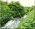
Oakham Nature Reserve, Mansfield, Notts.
A weir on the River Maun at the mid-point in this northern section of particular local nature reserve. This LNR is one of nine in the Mansfield area. The mid-point of the overall route, i.e. where the path crosses Hamilton Way and the southern section begins (or ends), is accessed is 10 minutes walk away behind the photographer. The other end of this northern section, i.e. on Hermitage Lane, is 10 minutes walk ahead.
Image: © David Hallam-Jones
Taken: 16 Jun 2013
0.04 miles
2
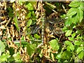
Dragonfly Resting
Photo taken by the path through the Oakham Local Nature Reserve. It is a southern hawker dragonfly (Aeshna cyanea). They are big - nearly 3 inches.
Image: © Antony Dixon
Taken: 23 Sep 2011
0.05 miles
3
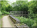
Oakham Nature Reserve, Mansfield, Notts.
A wooden bridge crosses the River Maun in the northern section of this local nature reserve. The mid-point of the overall route, i.e. where the path crosses Hamilton Way and the next section, the southern section, is accessed is 3-4 minutes walk ahead. The end (or start) of this northern section, i.e. on Hermitage Lane, is 10 minutes walk away behind the photographer.
Image: © David Hallam-Jones
Taken: 16 Jun 2013
0.07 miles
4
Oakham Nature Reserve, Mansfield, Notts.
Hamilton Way (ahead) is the cross-over point between the northern section and the southern sections of this local nature reserve. Access to the southern section is via a stile behind the belisha beacon.
Image: © David Hallam-Jones
Taken: 16 Jun 2013
0.08 miles
5
Oakham Nature Reserve, Mansfield, Notts.
The Hamilton Way entrance into the southern section of this local nature reserve (LNR).
Image: © David Hallam-Jones
Taken: 16 Jun 2013
0.10 miles
7
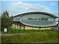
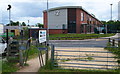
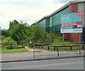
Futuristic Office Building
The iCentre on Oakham Business Park
Image: © Antony Dixon
Taken: 23 Sep 2011
0.12 miles
8
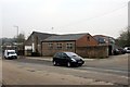
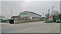
Industrial premises on Sheepbridge Lane
Image: © Graham Hogg
Taken: 31 Mar 2014
0.13 miles
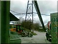
9
Recycling facility off Sheepbridge Lane, Mansfield
Image: © Chris Morgan
Taken: 31 Mar 2014
0.13 miles
10
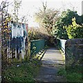
Bleak Hill Sidings, Sheepbridge Lane, Mansfield, Notts.
A 150 metre stroll up a gently sloping service road (a track), off the left-hand side of Sheepbridge Lane (marked by the entrance gates into the premises of ICS Waste Management plc.) leads to this footbridge that crosses Sheepbridge Lane. The footpath ahead passes behind the new "Heritage Park" housing development. It is part of a centuries old unmade path leading towards what is now the Portland Retail Park near to the town centre. The path is known locally as Cinderella Walk, perhaps because of past associations with burnt fuel residue, i.e. cinders. 400-500 metres along this path there is also the option to make a right-hand turn and thereby to access Quarry Lane Nature Reserve and the River Maun.
Image: © David Hallam-Jones
Taken: 19 Nov 2017
0.14 miles