IMAGES TAKEN NEAR TO
Mayflower Court, MANSFIELD, NG18 5AY
Introduction
This page details the photographs taken nearby to Mayflower Court, NG18 5AY by members of the Geograph project.
The Geograph project started in 2005 with the aim of publishing, organising and preserving representative images for every square kilometre of Great Britain, Ireland and the Isle of Man.

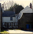
There are currently over 7.5m images from over14,400 individuals and you can help contribute to the project by visiting https://www.geograph.org.uk
Image Map
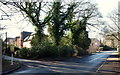
Images are licensed for reuse under creativecommons.org/licenses/by-sa/2.0
Notes
- Clicking on the map will re-center to the selected point.
- The higher the marker number, the further away the image location is from the centre of the postcode.
Image Listing (22 Images Found)
Images are licensed for reuse under creativecommons.org/licenses/by-sa/2.0
Image
Details
Distance
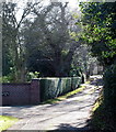
1
High Oakham Drive, Mansfield, Notts.
With the closed end of this cul-de-sac and High Oakham House (a former farm?) behind the photographer, this is a view of the lane as it continues towards Atkin Lane. A street name sign describing it's status as a "private road" (perhaps unadopted?) is situated at its junction with Atkin Lane.
Image: © David Hallam-Jones
Taken: 8 Feb 2015
0.03 miles
2
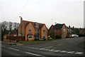
Paddock Close
Large, modern housing to the south west of the town centre.
Image: © Graham Hogg
Taken: 31 Mar 2014
0.09 miles
3
High Oakham Drive, Mansfield, Notts.
A former farm (?), High Oakham House, is just visible at the closed end of this cul-de-sac. A street name sign describing it's status as a "private road" (perhaps unadopted?) is situated at the side of the road near where it commences in Atkin Lane.
Image: © David Hallam-Jones
Taken: 8 Feb 2015
0.09 miles
4
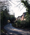
High Oakham Drive, Mansfield, Notts.
The lower, open end of this cul-de-sac is seen from its junction with Atkin Lane. A street name sign describing it's status as a "private road" (perhaps unadopted?) is situated nearby.
Image: © David Hallam-Jones
Taken: 8 Feb 2015
0.09 miles
5
High Oakham Drive, Mansfield, Notts.
High Oakham House (formerly a farm?) at the closed end of this 500 metre cul-de-sac.
Image: © David Hallam-Jones
Taken: 8 Feb 2015
0.10 miles
6
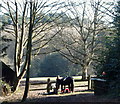
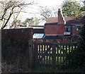
Paddock, High Oakham House Vicinity, Mansfield, Notts.
Grazing facilities at the end of a short track in the vicinity of High Oakham House (formerly a farm?) at the closed end of High Oakham Drive. The latter is described as "a private road" (perhaps an unadopted road?) on a street sign at the side of its exit on Atkin Lane.
Image: © David Hallam-Jones
Taken: 8 Feb 2015
0.11 miles
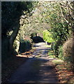
7
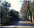
Atkin Lane, Mansfield, Notts.
With the main Mansfield-Nottingham road (the A60) 5 minutes walk away - behind the photographer - this is a view along Atkin Lane towards its continuous link with High Oakham Hill (< road name). High Oakham Drive is the turning on the left by the fence.
Image: © David Hallam-Jones
Taken: 8 Feb 2015
0.12 miles
8
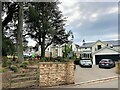
High Oakham Drive
New properties at High Oakham Park, which are built around the original house built by the 3rd Duke of Portland around 1750.
Image: © Jonathan Clitheroe
Taken: 20 Jul 2022
0.12 miles
9
Atkin Lane/High Oakham Drive Junction, Mansfield, Notts.
High Oakham Drive is seen here branching off Atkin Lane. Within several hundred metres - behind the photographer - Atkin Lane joins the main Nottingham-Mansfield Road (the A60).
Image: © David Hallam-Jones
Taken: 8 Feb 2015
0.12 miles
10
Gaywood Farm, Mansfield, Notts.
Farm buildings visible from the west side of a footpath that joins High Oakham Drive within a matter of hundred metres (to the left). The longest part of this path - to the right - exits adjacent to the main entrance of Mansfield Crematorium.
Image: © David Hallam-Jones
Taken: 8 Feb 2015
0.12 miles