IMAGES TAKEN NEAR TO
King Edward Avenue, MANSFIELD, NG18 5AF
Introduction
This page details the photographs taken nearby to King Edward Avenue, NG18 5AF by members of the Geograph project.
The Geograph project started in 2005 with the aim of publishing, organising and preserving representative images for every square kilometre of Great Britain, Ireland and the Isle of Man.

There are currently over 7.5m images from over14,400 individuals and you can help contribute to the project by visiting https://www.geograph.org.uk
Image Map
Images are licensed for reuse under creativecommons.org/licenses/by-sa/2.0
Notes
- Clicking on the map will re-center to the selected point.
- The higher the marker number, the further away the image location is from the centre of the postcode.
Image Listing (22 Images Found)
Images are licensed for reuse under creativecommons.org/licenses/by-sa/2.0
Image
Details
Distance
1
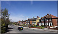
Hillsway Crescent, Mansfield, Notts.
The view towards Garth Road. Although houses now occupy the track bed, the railway line that ran beneath this bridge may once have belonged to the London, Midland and Scottish Railway (LMSR) Company? The creators of this route, i.e. the Midland Railway Company, opened a line from Nottingham to Kirkby on 2nd October 1848, extending it to Mansfield on 9 October 1849. Although a bill to allow for the line to be extended from Mansfield to Worksop failed in the 1860 session of Parliament, the bill was re-introduced several years later and the Mansfield Railways Act received the Royal Assent on 5 July 1865. Progress was slow and it was not until 1 June 1875 that the line was opened for traffic. The London, Midland and Scottish Railway (LMSR) was formed on 1 January 1923 under the Railways Act of 1921, which required the grouping of over 120 separate railways into four larger companies. The Nottingham-Worksop line, using this route south of Mansfield town centre, was closed 12 October 1964, under the Beeching rationalisation plans.
Image: © David Hallam-Jones
Taken: 19 Nov 2017
0.07 miles
2

Houses in Waverley Road, Mansfield
Image: © Jonathan Thacker
Taken: 13 Jan 2022
0.11 miles
3
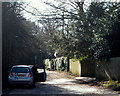
Bleak Hills Area, Mansfield, Notts.
Bleak Hills Lane seen from the point where Sheepbridge Lane and High Oakham Hill become one. Locals, who were younger in the 1940s, describe knowing Bleak Hills Lane as a cinder track that was also known as Harvey's Lane. It leads past Bleak Hill Dam (a former mill pond, now a private fishing location) as far as the site of a former cottage called Beeton's Cottage that is hosts a large house called Bleak Hills House. A 'footpath only' continues beyond this replacement house to Hamilton Way on the edge of the Bleak Hills Industrial Zone.
Image: © David Hallam-Jones
Taken: 16 Jun 2013
0.12 miles
4
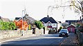
Waverley Road, Mansfield, Notts.
The left-hand corner site is occupied by three almshouses. No plaques or identification visible. The A60 between Nottingham-Mansfield can be seen ahead.
Image: © David Hallam-Jones
Taken: 19 Nov 2017
0.12 miles
5
Waverley Road, Mansfield, Notts.
Three almshouses at the Nottingham Road end of Waverley Road. Local maps identify them as almshouses although there were no obvious name plaques. The main Mansfield - Nottingham road is situated a stone's throw to the right.
Image: © David Hallam-Jones
Taken: 19 Nov 2017
0.12 miles
6
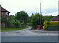
Sheepbridge Lane
On the outskirts of Mansfield. Named after the old sheep bridge which crosses the road at SK 528600.
Image: © Andy Stephenson
Taken: 17 Apr 2005
0.13 miles
7

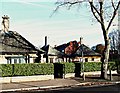
William Singleton Almshouses, Waverley Road, Mansfield
Designed by F.W. Tempest 1936. One of three linked buildings.
Image: © Jonathan Thacker
Taken: 13 Jan 2022
0.13 miles
8
Cherry Lane, Mansfield, Notts.
The High Oakham Road/Atkin Lane Junction lies immediately beyond the road sign that is visible at the other end of this un-made (and perhaps unadopted?) road.
Image: © David Hallam-Jones
Taken: 8 Feb 2015
0.14 miles
9
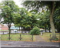
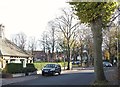
Mansfield, Notts.
A small triangular public garden separates Alexandra Avenue, seen in the forefront of the picture, from Nottingham Road (the A60) behind it. The traffic on this main road is travelling towards the town centre, having come from the Newstead, Harlow Wood and Nottingham direction.
Image: © David Hallam-Jones
Taken: 13 Sep 2013
0.15 miles
10
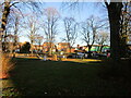
Small park off Waverley Road, Mansfield
Image: © Jonathan Thacker
Taken: 13 Jan 2022
0.16 miles