IMAGES TAKEN NEAR TO
Arches Road, MANSFIELD, NG18 4YR
Introduction
This page details the photographs taken nearby to Arches Road, NG18 4YR by members of the Geograph project.
The Geograph project started in 2005 with the aim of publishing, organising and preserving representative images for every square kilometre of Great Britain, Ireland and the Isle of Man.

There are currently over 7.5m images from over14,400 individuals and you can help contribute to the project by visiting https://www.geograph.org.uk
Image Map
Images are licensed for reuse under creativecommons.org/licenses/by-sa/2.0
Notes
- Clicking on the map will re-center to the selected point.
- The higher the marker number, the further away the image location is from the centre of the postcode.
Image Listing (2 Images Found)
Images are licensed for reuse under creativecommons.org/licenses/by-sa/2.0
Image
Details
Distance
1
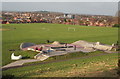
Fisher Lane Park, Mansfield, Notts.
Mansfield's Skate Plaza, that opened on December 2009, represents a relatively new concept (the first one having been built in the USA in 2005). A Skate Plaza is designed to recreate the urban street environment which many riders and skaters enjoy that uses materials that are commonly found in urban environments e.g. granite marble which is good for grinding and sliding. This one is seen from a flight of steps plus a footpath that descends from Windsor Road and links to Fisher Lane. This point on Windsor Road is also where The Timberland Trail and the Mansfield Trail cross. Other parts of Mansfield feature in the distance.
Image: © David Hallam-Jones
Taken: 11 Jan 2015
0.20 miles
2
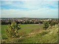
Playing fields and recreation ground, with view over Mansfield
Playing fields and recreation ground off Berry Hill Road and Forest Road seen from the bank on the western side of Berry Hill Road, with view over Mansfield towards the landscaped former
Sherwood Colliery spoil heap.
Image: © Antony Dixon
Taken: 27 Sep 2011
0.25 miles