IMAGES TAKEN NEAR TO
Black Rock Way, MANSFIELD, NG18 4YE
Introduction
This page details the photographs taken nearby to Black Rock Way, NG18 4YE by members of the Geograph project.
The Geograph project started in 2005 with the aim of publishing, organising and preserving representative images for every square kilometre of Great Britain, Ireland and the Isle of Man.

There are currently over 7.5m images from over14,400 individuals and you can help contribute to the project by visiting https://www.geograph.org.uk
Image Map
Images are licensed for reuse under creativecommons.org/licenses/by-sa/2.0
Notes
- Clicking on the map will re-center to the selected point.
- The higher the marker number, the further away the image location is from the centre of the postcode.
Image Listing (3 Images Found)
Images are licensed for reuse under creativecommons.org/licenses/by-sa/2.0
Image
Details
Distance
1
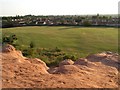
Forest Road Recreation Ground
A sandstone outcrop off Berry Hill Road, then the rec and some houses built in the 1970s and 80s.
Much of this area was formerly a sand quarry, closed many years ago.
Image: © Peter Kochut
Taken: 27 Jun 2005
0.23 miles
3
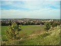
Playing fields and recreation ground, with view over Mansfield
Playing fields and recreation ground off Berry Hill Road and Forest Road seen from the bank on the western side of Berry Hill Road, with view over Mansfield towards the landscaped former
Sherwood Colliery spoil heap.
Image: © Antony Dixon
Taken: 27 Sep 2011
0.25 miles