IMAGES TAKEN NEAR TO
Abbeydale Drive, MANSFIELD, NG18 4TL
Introduction
This page details the photographs taken nearby to Abbeydale Drive, NG18 4TL by members of the Geograph project.
The Geograph project started in 2005 with the aim of publishing, organising and preserving representative images for every square kilometre of Great Britain, Ireland and the Isle of Man.

There are currently over 7.5m images from over14,400 individuals and you can help contribute to the project by visiting https://www.geograph.org.uk
Image Map
Images are licensed for reuse under creativecommons.org/licenses/by-sa/2.0
Notes
- Clicking on the map will re-center to the selected point.
- The higher the marker number, the further away the image location is from the centre of the postcode.
Image Listing (28 Images Found)
Images are licensed for reuse under creativecommons.org/licenses/by-sa/2.0
Image
Details
Distance
1
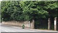
Lichfield Lane, Mansfield, Notts.
This site, off the east side of Lichfield Lane - in the Berry Hill area of Mansfield - previously housed offices belonging to the National Coal Board and its successor(s) but it is now shared by several N.H.S. administrative units. The Coal Authority manages the effects of past coal mining, including subsidence damage claims which are not the responsibility of licensed coal mine operators. It deals with mine water pollution and other mining legacy issues. The Coal Authority is an executive non-departmental public body sponsored by the Department for Business, Energy & Industrial Strategy.
Image: © David Hallam-Jones
Taken: 16 Jul 2017
0.10 miles
2
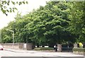
Berry Hill Park, Mansfield, Notts.
One of the entrances, off the east side of Lichfield Lane - into Berry Hill Park. Beyond the bus stop is the entrance into a multi-unit commercial site shared by The Coal Authority, the NHS Business Services organisation and a local NHS administrative unit.
Image: © David Hallam-Jones
Taken: 16 Jul 2017
0.11 miles
3

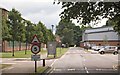
Berry Hill Park, Mansfield, Notts.
A view from Lichfield Lane. This entrance - on the west side of the park - provides access for vehicles and leads to the cafe, the children's playground, the lake, the bandstand and the modern athletics track.
Image: © David Hallam-Jones
Taken: 16 Jul 2017
0.11 miles
4
Coal Authority Site, Lichfield Lane, Mansfield, Notts
This site, off the east side of Lichfield Lane - in the Berry Hill area of Mansfield - previously housed offices belonging to the National Coal Board and its successor(s) but it is now shared by several N.H.S. administrative units. The Coal Authority manages the effects of past coal mining, including subsidence damage claims which are not the responsibility of licensed coal mine operators. It deals with mine water pollution and other mining legacy issues. The Coal Authority is an executive non-departmental public body sponsored by the Department for Business, Energy & Industrial Strategy.
Image: © David Hallam-Jones
Taken: 16 Jul 2017
0.11 miles
5
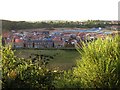
New houses on Berry Hill Sand Quarry site
Much of Mansfield is built on sandstone. It has been quarried for many years and used for moulds in ironfounding. Together with locally available coal this was the basis of several former ironfoundries in the town. This quarry, now closed is being used for new housing.
In the 1960s I remember walking here, along a public footpath through a field of wheat or barley, before the quarrying dug so deeply.
Image: © Peter Kochut
Taken: 27 Jun 2005
0.12 miles
6
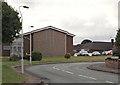
Southridge Drive, Mansfield, Notts.
A view of the Church of Jesus Christ of Latter Day Saints in the Robin Down's Hill area.
Image: © David Hallam-Jones
Taken: 16 Jul 2017
0.13 miles
7
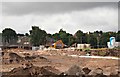
Robin Down's Hill Vicinity, Mansfield, Notts.
Housing construction on a brown field site on the opposite side of the road to the entrances into Nottingham Road Cemetery, i.e. on the east side of the A60. This view is from a footpath linking Nottingham Road and The Oaks (a residential road). The older houses behind the mechanical digger seem likely to be on Robin Down Lane. In 1767, a half-witted travelling busker called Robin Down was playing his flute in the town. A group of boys tormented him to the point where he stabbed one of them. The boy died and Robin Down was apprehended and taken to Nottingham to be tried. In a bid to prove his sanity, the judge, offered Robin Down a choice of two coins, one silver and one gold. As a result of choosing the gold coin because it was 'the shiniest and the most valuable', the judge deemed that he was sane enough to stand trial. He was sentenced and subsequently hanged in Nottingham. His dismembered body was hung on chains at this spot and Robin Down Hill (and Lane) still exist today as a reminder of these events.
Image: © David Hallam-Jones
Taken: 16 Jul 2017
0.20 miles
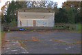
9
Berry Hill Park, Mansfield, Notts.
The children's play area, some elderly changing facilities(?) and a telecommunications mast.
Image: © David Hallam-Jones
Taken: 16 Jul 2017
0.20 miles
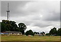
10

Berry Hill Park, Mansfield, Notts.
The lake, the bandstand and Lichfield Wood. Lichfield Lane, a busy link road in the Berry Hill area, lies behind the trees.
Image: © David Hallam-Jones
Taken: 16 Jul 2017
0.20 miles