IMAGES TAKEN NEAR TO
Chatsworth Drive, MANSFIELD, NG18 4QX
Introduction
This page details the photographs taken nearby to Chatsworth Drive, NG18 4QX by members of the Geograph project.
The Geograph project started in 2005 with the aim of publishing, organising and preserving representative images for every square kilometre of Great Britain, Ireland and the Isle of Man.

There are currently over 7.5m images from over14,400 individuals and you can help contribute to the project by visiting https://www.geograph.org.uk
Image Map
Images are licensed for reuse under creativecommons.org/licenses/by-sa/2.0
Notes
- Clicking on the map will re-center to the selected point.
- The higher the marker number, the further away the image location is from the centre of the postcode.
Image Listing (6 Images Found)
Images are licensed for reuse under creativecommons.org/licenses/by-sa/2.0
Image
Details
Distance
1
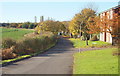
Old Newark Road, Mansfield, Notts.
Old Newark Road is seen here forming the southern boundary of the Bellamy Road (residential) Estate. This is another section of the former Old Newark Road that is still maintained as a usable road, most of this 4-5 mile former road having been left unmaintained as a rough-and-ready cycle track and a pedestrian shortcut between the A6191 (a.k.a. Southwell Road East) and the A60 (main Mansfield-Nottingham) Road, near the West Notts College site. The turning to the right is Newark Drive.
Image: © David Hallam-Jones
Taken: 10 Nov 2013
0.11 miles
2
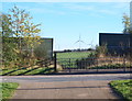
Old Newark Road, Mansfield, Notts.
On the other side of the A6117 dual carriageway (a.k.a. Adamsway), between the high fences, a surfaced footpath leads 150 yds downhill until it reaches the south-westerly edge of the Bellamy Road (residential) Estate and a mile long properly-maintained stretch of the former Old Newark Road (still called Old Newark Road). The eastern section of the former Old Newark Road, on this side of the road, gives the impression of being maintained in a usable condition however, within 50 yds the route resorts to being a rough-and-ready track that is only suitable for mountain bikers, pedestrians and horses-riders. The Lindhurst Wind Farm can is also visible in the distance.
Image: © David Hallam-Jones
Taken: 10 Nov 2013
0.14 miles
3
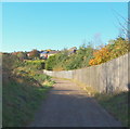
Former Old Newark Road, Mansfield, Notts.
Part of the eastern section of the former Old Newark Road is seen here from where the A6117 dual carriageway (a.k.a. Adamsway) bisects the former Old Newark Road. The first impression that users get of the route ahead is that the road is maintained in a perfectly usable condition. However, within 50 yds the route resorts to being a rough-and-ready track that is only suitable for mountain bikers, pedestrians and horses-riders. Residential accommodation on Chatsworth Drive exists behind the wooden fence/s, whereas on the right - beyond the gorse and brambles - arable land exists. 3 miles or so ahead this track joins the western-most section of the former Old Newark Road, that is maintained because houses and gardens open onto it.
Image: © David Hallam-Jones
Taken: 10 Nov 2013
0.15 miles
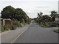
4
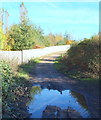
Former Old Newark Road, Mansfield, Notts.
A 200 yd maintained section of the former Old Newark Road that connects this unmaintained section to the A6117 Road (a.k.a. Adamsway) on the brow of this incline. No vehicular access is allowed onto or from the A6117, although mountain-bikers, pedestrians and horse-riders can cross this dual carriageway and access a mile long length of the eastern section of the former Old Newark Road that IS maintained because it serves the south-western edge of the Bellamy Road (residential) Estate. Houses on Chatsworth Drive exist on land behind the wooden fence/s, whereas to the photographer's right is exclusively arable land.
Image: © David Hallam-Jones
Taken: 10 Nov 2013
0.15 miles
5
Thorpe Road
one of the newer roads in Mansfield
Image: © Tom Courtney
Taken: 9 Oct 2005
0.16 miles
6
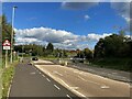
Approaching Roundabout on the A6117
Image: © Jonathan Clitheroe
Taken: 8 Oct 2022
0.21 miles