IMAGES TAKEN NEAR TO
Oak Avenue, MANSFIELD, NG18 2AP
Introduction
This page details the photographs taken nearby to Oak Avenue, NG18 2AP by members of the Geograph project.
The Geograph project started in 2005 with the aim of publishing, organising and preserving representative images for every square kilometre of Great Britain, Ireland and the Isle of Man.

There are currently over 7.5m images from over14,400 individuals and you can help contribute to the project by visiting https://www.geograph.org.uk
Image Map
Images are licensed for reuse under creativecommons.org/licenses/by-sa/2.0
Notes
- Clicking on the map will re-center to the selected point.
- The higher the marker number, the further away the image location is from the centre of the postcode.
Image Listing (64 Images Found)
Images are licensed for reuse under creativecommons.org/licenses/by-sa/2.0
Image
Details
Distance
2
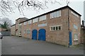
The Coachhouse
A late 19th century addition to Carr Bank this stands behind Image but is not part of the listed building status. Run separately from the hotel it provides a meeting room and a cafe for users of the park.
Image: © Bob Harvey
Taken: 10 Mar 2016
0.02 miles
3
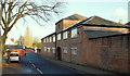
Windmill Lane, Mansfield, Notts.
The former Carr Bank House stables, c.1805. The main house (now The Mansfield Manor Hotel), was once the family home of a local cotton industrialist, a Mr Stanton. Since the main house was previously used as office space for local Council staff, perhaps the converted stables were too? Now however, there is a café situated on the first floor and two shops on the ground floor. The main house, behind this block, overlooks Carr Bank Park.
Image: © David Hallam-Jones
Taken: 8 Jan 2015
0.02 miles
5
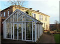
Former Carr Bank House, Mansfield, Notts.
A green house and garden path on the south side of the former Carr Bank House (now a hotel). The front of the hotel (ahead) overlooks the larger, grassed, part of the park but members of the public also have access to this area. Carr Bank House - now The Mansfield Manor Hotel - and it's gardens were built and created by the Stanton family c.1805. Their wealth was derived from on the cotton industry boom during the Industrial Revolution. This 'estate' was later sold to the 4th Duke of Portland who was influential in shaping Mansfield and it's facilities. The Allotment Commissioners leased land from the Duke for the use of local people and these gardens became the town's first public park.
The 6th Duke sold the house and grounds at the end of WWI to provide the town with a memorial park to the thousands who had died. A war memorial was unveiled on 4th August 1921 and the park was opened to the public in 1924.
Image: © David Hallam-Jones
Taken: 8 Jan 2015
0.03 miles
6
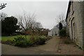
Greenhouse and Garden
An early 20th century greenhouse to the side of Image, and that part of the park which was once the kitchen garden of the house.
Image: © Bob Harvey
Taken: 10 Mar 2016
0.03 miles
7
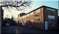
Windmill Lane, Mansfield, Notts.
The former Carr Bank House stables, c.1805. A corner of the main house (now The Mansfield Manor Hotel) - once the family home of a local cotton industrialist, Mr Stanton - is visible on the left. Since the main house was previously used as office space for local Council staff perhaps the converted stables were too? Now however, there is a café situated on the first floor and two shops on the ground floor. Windmill Lane is situated behind this block running parallel with the former stables. The main house overlooks the park.
Image: © David Hallam-Jones
Taken: 8 Jan 2015
0.03 miles
8
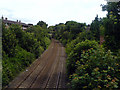
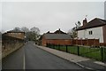
Robin Hood Line, Mansfield
The Robin Hood Line as it passes beneath the bridge next to Carr Bank Park in Mansfield.
Image: © James Hill
Taken: 2 Jul 2007
0.04 miles