IMAGES TAKEN NEAR TO
Walkden Street, MANSFIELD, NG18 1QN
Introduction
This page details the photographs taken nearby to Walkden Street, NG18 1QN by members of the Geograph project.
The Geograph project started in 2005 with the aim of publishing, organising and preserving representative images for every square kilometre of Great Britain, Ireland and the Isle of Man.

There are currently over 7.5m images from over14,400 individuals and you can help contribute to the project by visiting https://www.geograph.org.uk
Image Map
Images are licensed for reuse under creativecommons.org/licenses/by-sa/2.0
Notes
- Clicking on the map will re-center to the selected point.
- The higher the marker number, the further away the image location is from the centre of the postcode.
Image Listing (257 Images Found)
Images are licensed for reuse under creativecommons.org/licenses/by-sa/2.0
Image
Details
Distance
1
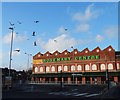
Walkden Street, Mansfield, Notts.
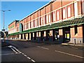
What is now known as the Rosemary Centre (a shopping centre) was constructed as "Lawn Mills" in 1906 by the Cash family. The mill was used to prepare cotton that was then sent on for weaving in the damper atmosphere of Lancashire.
Image: © David Hallam-Jones
Taken: 20 Jan 2017
0.02 miles
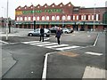
2
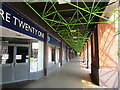
Colonnade, Rosemary Centre, Mansfield
Image: © Jonathan Thacker
Taken: 21 Jul 2019
0.02 miles
4
The Rosemary Centre
Shopping centre largely devoid of shops!
Image: © Jonathan Thacker
Taken: 21 Jul 2019
0.03 miles
5
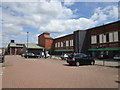
"The Rosemary Centre", Mansfield
A declining town centre shopping centre and a monument to architectural functionalism.
Image: © Neil Theasby
Taken: 8 Jan 2015
0.04 miles
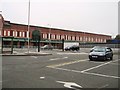
9
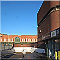
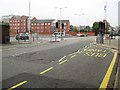
Former Bus Station, Mansfield, Notts.
The defunct Travel Centre that was part of the former bus station (1977-2013). In the background is the Rosemary (shopping) Centre, Walkden Street that is housed on the site of "Lawn Mills". This mill's function was to prepare cotton that was sent away for weaving in the damper atmosphere of Lancashire. The mill was owned by the Cash family.
Image: © David Hallam-Jones
Taken: 20 Jan 2017
0.05 miles
10
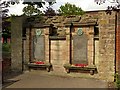
Memorial wall, The Old Meeting House, Mansfield
Listed Grade II, the description states:
"The Memorial Wall at the Old Meeting House Unitarian Chapel in Mansfield was built in the 1920's to the designs of Alan Sorby Buxton (1867-1932), a renowned local artist, local historian and antiquarian. It stands adjacent to Mansfield's Unitarian Chapel in Old Meeting House Yard . . . and commemorates those members of the chapel community who lost their lives in the First World War.”
Image: © Alan Murray-Rust
Taken: 21 Aug 2019
0.05 miles