IMAGES TAKEN NEAR TO
West Hill Avenue, MANSFIELD, NG18 1PQ
Introduction
This page details the photographs taken nearby to West Hill Avenue, NG18 1PQ by members of the Geograph project.
The Geograph project started in 2005 with the aim of publishing, organising and preserving representative images for every square kilometre of Great Britain, Ireland and the Isle of Man.

There are currently over 7.5m images from over14,400 individuals and you can help contribute to the project by visiting https://www.geograph.org.uk
Image Map
Images are licensed for reuse under creativecommons.org/licenses/by-sa/2.0
Notes
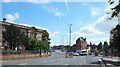
- Clicking on the map will re-center to the selected point.
- The higher the marker number, the further away the image location is from the centre of the postcode.
Image Listing (197 Images Found)
Images are licensed for reuse under creativecommons.org/licenses/by-sa/2.0
Image
Details
Distance
1
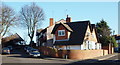
West Hill Drive Vicinity, Mansfield, Notts.
This cluster of houses occupy a corner site between West Hill Drive on the right and West Hill Avenue on the left. The wooden structure with the pitched roof at the closed end of West Hill Avenue is a probably the only structure still standing on the site of the town's former general hospital behind it. The hospital has been demolished and the council are currently taking public soundings about its plans to build 30-50 residential units for elderly people. Perhaps the wooden structure has been left for use as a shelter for the building contractors who will come onto the site shortly, or could it become a garden shelter for the future residents?
Image: © David Hallam-Jones
Taken: 15 Jan 2016
0.03 miles
2
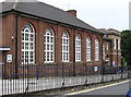
Mansfield - College of Art & Design
Frontage on Paulsons Drive. For an alternative view, please see Image
Image: © Dave Bevis
Taken: 17 Sep 2013
0.06 miles
3
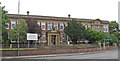
Mansfield - College of Art & Design
On Chesterfield Road South. Please see Image for an alternative view.
Image: © Dave Bevis
Taken: 17 Sep 2013
0.06 miles
4
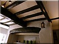
72 West Gate, Mansfield
Interior view showing wide fireplace with bressumer and main joists, probably from the original 17th century building. The current occupier said it had been a smithy, but this seems unlikely, and is probably based on the fireplace. This however is typically domestic of the period.
Image: © Alan Murray-Rust
Taken: 21 Aug 2019
0.06 miles
5
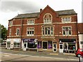
76-80 West Gate, Mansfield
Late 19th century commercial development, dated 1880 http://www.geograph.org.uk/photo/6256641 .
Image: © Alan Murray-Rust
Taken: 21 Aug 2019
0.06 miles
6
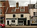
72 & 74 West Gate, Mansfield
Listed Grade II as having been one house, with later conversion to two shops, but possibly two dwellings from the outset. Late 17th century, with some original internal timbers remaining http://www.geograph.org.uk/photo/6256757, late 19th century shop front to no.72. The two 'shops' ( deli and tearoom) are part of the same business.
Image: © Alan Murray-Rust
Taken: 21 Aug 2019
0.06 miles
7
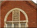
76-80 West Gate, Mansfield - detail
Florid date panel. See http://www.geograph.org.uk/photo/6256637 for location.
Image: © Alan Murray-Rust
Taken: 21 Aug 2019
0.07 miles
8
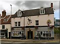
The New Inn, West Gate, Mansfield
Originally mid 17th century, the front shows remodelling from the 19th century (upper floors) and 20th century (ground floor). Listed Grade II.
Image: © Alan Murray-Rust
Taken: 21 Aug 2019
0.07 miles
9
Mansfield, Notts.
Chesterfield Road South (the A6009) at the foot of this picture becomes St Peter's Way (also the A6009) as it curves away to the left. An entrance or exit point into - or out of - Westgate (one of the town's main, pedestrianised shopping streets) is situated behind the white van. The Chesterfield Road campus building of the West Notts College - dating from 1928 - stands proudly on the left. This site provides facilities and educational opportunities for students studying fashion, art & design, and graphic design. It is also the college's ESOL (English For Speakers of Other Languages) base.
Image: © David Hallam-Jones
Taken: 13 Sep 2013
0.07 miles
10
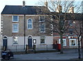
Westgate, Mansfield, Notts.
The Manor Pharmacy occupies at least part, if not all, of a former framework knitters' house at the St John's Street end of the now-pedestrianised Westgate.
Image: © David Hallam-Jones
Taken: 15 Jan 2016
0.07 miles