IMAGES TAKEN NEAR TO
Maun View, MANSFIELD, NG18 1NL
Introduction
This page details the photographs taken nearby to Maun View, NG18 1NL by members of the Geograph project.
The Geograph project started in 2005 with the aim of publishing, organising and preserving representative images for every square kilometre of Great Britain, Ireland and the Isle of Man.

There are currently over 7.5m images from over14,400 individuals and you can help contribute to the project by visiting https://www.geograph.org.uk
Image Map
Images are licensed for reuse under creativecommons.org/licenses/by-sa/2.0
Notes
- Clicking on the map will re-center to the selected point.
- The higher the marker number, the further away the image location is from the centre of the postcode.
Image Listing (344 Images Found)
Images are licensed for reuse under creativecommons.org/licenses/by-sa/2.0
Image
Details
Distance
1
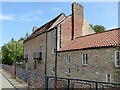
Rock Court, Mansfield
A group of late 17th century houses with stable and cart-shed, Listed Grade II. Currently unoccupied although refurbishment appears to have been undertaken in the late 20th or early 21st century. This is the rear of the building alongside the River Maun.
Image: © Alan Murray-Rust
Taken: 21 Aug 2019
0.02 miles
2
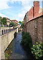
Mansfield, Notts (Maun Valley)
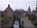
Ahead, having emerged from beneath The Bridge Inn, the River Maun continues its journey northwards. The footpath behind the ornamental railings is part of the Maun Valley Trail. "Rock Court", on the right, is now a residential complex. It was built in the C17th (perhaps as a mill or mill warehouse?) but in 1863 was converted in Maltby's Academy, a private school for boys. It was run by three generations of the Maltby family until 1887.
Behind the houses on the left is a road called Rock Valley, an area that once housed the Metal Box Company factory.
Image: © David Hallam-Jones
Taken: 15 Jul 2012
0.02 miles
3
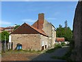
Rock Court, Mansfield
A group of late 17th century houses with stable and cart-shed, Listed Grade II. Currently unoccupied although refurbishment appears to have been undertaken in the late 20th or early 21st century.
Image: © Alan Murray-Rust
Taken: 21 Aug 2019
0.02 miles
4
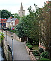
Mansfield, Notts (Maun Valley)
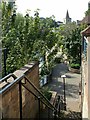
Hesitating on the steep flight of steps that carry the Maun Valley Trail path northwards up onto a road called Rock Court, I took this photograph as I looked back towards the Bridge Inn and the Parish Church area.
Image: © David Hallam-Jones
Taken: 15 Jul 2012
0.03 miles
5
Mansfield - Maun Valley Trail
North of Bridge Street.
Image: © Dave Bevis
Taken: 12 Apr 2004
0.03 miles
6
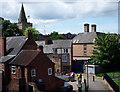
Mansfield, Notts (Bridge Inn)
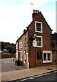
The view from the Methodist Church's upper level car park. A footpath at the side of the Bridge Inn is visible that forms part of the Maun Valley Trail. Rehearsals were occurring in the pub car park on the day that the photograph was taken for part of the outdoor play that formed the penultimate feature of the 2012 Mansfield Cultural Festival. Beyond the prefabricated garage and the blue-painted gates of a shop's storage area the Grade II-listed late 17th century building with the tall chimneys is St Peter's House. Formerly a private house and then a bank, it is now occupied by a firm of solicitors. The tower and spire of the Grade I-listed Parish Church in Church Street is also visible, its tower dating from 1603 and its spire from 1699.
Image: © David Hallam-Jones
Taken: 15 Jul 2012
0.03 miles
7
Maun Valley Way
Modern urban redevelopment alongside the River Maun.
Image: © Alan Murray-Rust
Taken: 21 Aug 2019
0.04 miles
8
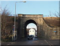
Toothill Lane, Mansfield, Notts.
The south side of a railway bridge looking towards the town centre section of Toothill Lane in the town centre. The bridge carries the Robin Hood Line railway service between Mansfield and Mansfield Woodhouse.
Image: © David Hallam-Jones
Taken: 8 Jan 2015
0.04 miles
9
Mansfield, Notts (Bridge St)
Opposite the Stanhope Hall - that is located above a parade of shops on Bridge Street - is The Bridge Tavern, adjacent to the River Maun (from whence the name Mansfield is derived). From here, amongst other points, the Maun Valley Trail can be accessed by walkers.
Image: © David Hallam-Jones
Taken: 19 Jun 2012
0.04 miles
10
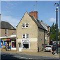
5 Bridge Street, Mansfield
Late 17th century house with later modifications including conversion to retail use. Listed Grade II.
Image: © Alan Murray-Rust
Taken: 21 Aug 2019
0.04 miles