IMAGES TAKEN NEAR TO
Toothill Lane, MANSFIELD, NG18 1NJ
Introduction
This page details the photographs taken nearby to Toothill Lane, NG18 1NJ by members of the Geograph project.
The Geograph project started in 2005 with the aim of publishing, organising and preserving representative images for every square kilometre of Great Britain, Ireland and the Isle of Man.

There are currently over 7.5m images from over14,400 individuals and you can help contribute to the project by visiting https://www.geograph.org.uk
Image Map
Images are licensed for reuse under creativecommons.org/licenses/by-sa/2.0
Notes
- Clicking on the map will re-center to the selected point.
- The higher the marker number, the further away the image location is from the centre of the postcode.
Image Listing (392 Images Found)
Images are licensed for reuse under creativecommons.org/licenses/by-sa/2.0
Image
Details
Distance
1
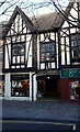
Handley Arcade, Mansfield, Notts.
A view of the faux-Tudor Handley Arcade façade, Toothill Street.
Image: © David Hallam-Jones
Taken: 8 Jan 2015
0.01 miles
2

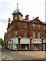
Brunts Buildings, Leeming Street, Mansfield
Commercial development dated 1915, designed by Arthur C. Howard,
architect to the Trustees of Brunts Charity, Listed Grade II.
The name derives from Samuel Brunts who founded a charity to provide almshouses in the Mansfield area. The charity occupies offices in the building which suggests that the development was effected to provide income to the charity.
Image: © Alan Murray-Rust
Taken: 21 Aug 2019
0.01 miles
3
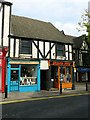
7 & 9 Toothill Street, Mansfield
The timbering is sham, probably 20th century, but is thought to cover original timbering, the buildings dating back to the late 17th century. Listed Grade II.
Image: © Alan Murray-Rust
Taken: 21 Aug 2019
0.02 miles
4
Brunts Buildings, Leeming Street, Mansfield
Commercial development dated 1915, designed by Arthur C. Howard,
architect to the Trustees of Brunts Charity, Listed Grade II.
The name derives from Samuel Brunts who founded a charity to provide almshouses in the Mansfield area, and whose statue adorns the corner of the building. The charity occupies offices in the building which suggests that the development was effected to provide income to the charity.
See also http://www.geograph.org.uk/photo/6259585 and http://www.geograph.org.uk/photo/6259586
Image: © Alan Murray-Rust
Taken: 21 Aug 2019
0.02 miles
5
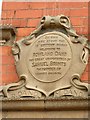
Brunts Buildings, Leeming Street, Mansfield
Memorial plaque. See http://www.geograph.org.uk/photo/6259585 for location.
Image: © Alan Murray-Rust
Taken: 21 Aug 2019
0.02 miles
6

Toothill Lane, Mansfield, Notts.
The Brunts Charity, Mansfield was established as the result of a bequest of Samuel Brunt's in 1711. The charity's office is based here at the corner of Toothill Lane and Leeming Street in the town centre. The trust is managed by eleven Trustees from the Mansfield area and it provides over 150 almshouse properties within three town centre locations.
Image: © David Hallam-Jones
Taken: 7 Jan 2017
0.02 miles
7
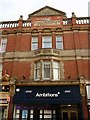
Imperial Buildings, Leeming Street, Mansfield - detail
Classic commercial redevelopment from the turn of the 20th century. Dated 1901, with modernised shop fronts from the later 20th century. Listed Grade II.
Image: © Alan Murray-Rust
Taken: 21 Aug 2019
0.03 miles
8
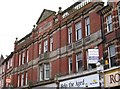
Mansfield - Imperial Buildings
On Leeming Street.
Image: © Dave Bevis
Taken: 12 Mar 2009
0.03 miles
9
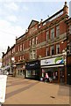
Imperial Buildings, Leeming Street, Mansfield
Classic commercial redevelopment from the turn of the 20th century. Dated 1901, with modernised shop fronts from the later 20th century. Listed Grade II.
Image: © Alan Murray-Rust
Taken: 21 Aug 2019
0.03 miles
10
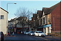
Toothill Lane, Mansfield, Notts.
The town centre section of Toothill Lane with a view of the faux-Tudor Handley Arcade facade.
Image: © David Hallam-Jones
Taken: 8 Jan 2015
0.03 miles