IMAGES TAKEN NEAR TO
Station Road, MANSFIELD, NG18 1LP
Introduction
This page details the photographs taken nearby to Station Road, NG18 1LP by members of the Geograph project.
The Geograph project started in 2005 with the aim of publishing, organising and preserving representative images for every square kilometre of Great Britain, Ireland and the Isle of Man.

There are currently over 7.5m images from over14,400 individuals and you can help contribute to the project by visiting https://www.geograph.org.uk
Image Map
Images are licensed for reuse under creativecommons.org/licenses/by-sa/2.0
Notes
- Clicking on the map will re-center to the selected point.
- The higher the marker number, the further away the image location is from the centre of the postcode.
Image Listing (363 Images Found)
Images are licensed for reuse under creativecommons.org/licenses/by-sa/2.0
Image
Details
Distance
1
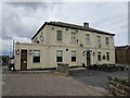
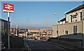
The Midland Hotel, Mansfield
Dates from about 1820. It predates the railway but the arrival of the railway precipitated its change from a house to a hotel. https://historicengland.org.uk/listing/the-list/list-entry/1288143
Image: © Jonathan Thacker
Taken: 21 Jul 2019
0.00 miles
2
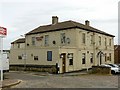
Midland Hotel, Mansfield
Appearing to be a classic railway hotel, adjacent to the railway station, it started life as a private residence in c.1820, not being converted to a hotel until c.1870. Listed Grade II.
Image: © Alan Murray-Rust
Taken: 21 Aug 2019
0.00 miles
3
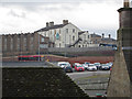
Mansfield - Midland Hotel
As seen from the Walkden Street multi-storey car park. The hotel is the white building in the centre of the photo. The railway station can just be seen to the right of the hotel. The hotel is named after the railway company that built the station (the Midland Railway Company).
Image: © Dave Bevis
Taken: 12 Feb 2016
0.01 miles
4
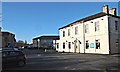
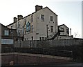
Station Vicinity, Mansfield, Notts.
This is the oldest part of The Midland Hotel. It was built in 1805 as an lunatic asylum for men and had high walls around it. It was known as Broom House until The Midland Railway Company purchased it in 1862 and converted it into a hotel. The hotel yard served as a venue for auctions, including for the sale of horses. There is a large modern extension to the photographer's right and as a result of this, the establishment now serves as a function venue and public house. Behind the tall "Mansfield Station" sign are modern premises housing the local probation service offices, whilst on the left is the booking office entrance to the railway station.
Image: © David Hallam-Jones
Taken: 20 Jan 2017
0.01 miles
5
Station Road, Mansfield, Notts.
The Midland Hotel was built in 1805 as an lunatic asylum for men and it had high walls around it. It was known as Broom House until The Midland Railway Company purchased it in 1862 and converted it into a hotel. It is now a function venue and public house. The red car is facing in the direction of the new bus station 100 metres ahead of it. The entrance into the station, via its booking office, is behind the photographer. In the distance is The Rosemary Centre, a shopping centre, that was originally "Lawn Mills". This mill prepared cotton that was then sent for weaving in Lancashire, which is the damper. The mill was owned by the Cash family.
Image: © David Hallam-Jones
Taken: 20 Jan 2017
0.02 miles
6
Bus Station Vicinity, Mansfield, Notts.
Bus passengers looking out from the glass-walled waiting areas of the new bus station can't help but notice The Midland Hotel. It was built in 1805 as an lunatic asylum for men with high walls around it. It was known as Broom House until The Midland Railway Company purchased it in 1862 and when it converted it into a hotel. It is now a function venue and public house. The railway station's main entrance and booking office lies behind it, as does the busy A6009.
Image: © David Hallam-Jones
Taken: 20 Jan 2017
0.02 miles
7
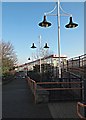
Station Vicinity, Mansfield, Notts.
The entrance into an enclosed, raised walkway that connects the railway station and the bus station is visible behind the nearest lamp-post. This is used to convey passengers over the tops of buses in the manoeuvring area below it. Passengers also have the option to descend this ramp into Quaker Way that runs parallel with the front of the bus station.
Image: © David Hallam-Jones
Taken: 20 Jan 2017
0.02 miles
8
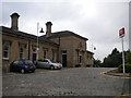
Bus station roadway and Midland Hotel extension, Mansfield
There is a bench mark http://www.geograph.org.uk/photo/6248515 on the retaining wall on the left.
Image: © Alan Murray-Rust
Taken: 21 Aug 2019
0.02 miles
9
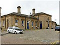
Mansfield Station, forecourt side
Built by the Midland Railway in 1872 in Classical style, Listed Grade II. Well restored as part of the reopening of the railway between Nottingham and Mansfield around 2000.
Image: © Alan Murray-Rust
Taken: 21 Aug 2019
0.02 miles
10
Station forecourt, Mansfield
Officially named simply "Mansfield", this station is often referred to unofficially as "Mansfield Town" (particularly by train guards) to differentiate it from Mansfield Woodhouse (the next station north of here). This is even reflected in the station's CRS code: MFT.
Image: © Richard Vince
Taken: 14 Jun 2014
0.02 miles