1
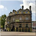
3 Market Street, Mansfield
A small former bank building, dated 1889, Listed Grade II.
Image: © Alan Murray-Rust
Taken: 21 Aug 2019
0.00 miles
2
The Byron, Market Street, Mansfield
Former Mansfield Bank building, c.1900, in Baroque Revival style, Listed Grade II.
Image: © Alan Murray-Rust
Taken: 21 Aug 2019
0.01 miles
3
Mansfield - The Byron (pub)
Nos 1 and 2 Market Street. Former NatWest bank.
Image: © Dave Bevis
Taken: 18 Jul 2016
0.01 miles
4
Mansfield, Notts (Viaduct)
A view along White Hart Street in the direction of Church Street. The railway station is situated a good few metres behind the photographer. Selected old photographs of this view show shops occupying these arches. Although this 15-arched viaduct, 60ft above the ground, was constructed between 1871-72 it remained unused until 1875 due to a tunnel having to be lined in the Cresswell area. The line was opened for goods traffic on 22 January 1875 but not for passenger trains until 1 June of that year. At 07.10hrs on that date over 100 passengers boarded a train that slowly crossed the new viaduct. Most of these passengers then alighted at the Mansfield Woodhouse station and walked back to Mansfield ready to begin their daily chores. T It seems that they had only travelled on the train for the sheer joy of crossing this magnificent edifice.
Image: © David Hallam-Jones
Taken: 20 Jun 2012
0.02 miles
5
Railway Viaduct, Mansfield
Railway viaduct, White Hart Street, Mansfield.
Carries the Robin Hood line from Nottingham to Worksop.
Image: © Peter Kochut
Taken: 7 Dec 2003
0.02 miles
6
Bench mark, Mansfield Viaduct
On the pier adjacent to the Queen Street arch.
Image: © Alan Murray-Rust
Taken: 21 Aug 2019
0.02 miles
7
Mansfield Viaduct, top of White Hart Street
The second arch, crossing Queen Street, is wider, and has a different treatment of the voussoirs http://www.geograph.org.uk/photo/6259639 . Listed Grade II.
Image: © Alan Murray-Rust
Taken: 21 Aug 2019
0.02 miles
8
Mansfield Viaduct, Queen Street
This arch has dressed voussoirs, in contrast to the rock-faced treatment of the other arches. Built c.1875 by the Midland Railway, Listed Grade II.
Image: © Alan Murray-Rust
Taken: 21 Aug 2019
0.02 miles
9
Mansfield Viaduct
The viaduct, built in the 1870s and Listed Grade II, strides through the centre of the town. This is the view down Dame Flogan Street.
Image: © Alan Murray-Rust
Taken: 21 Aug 2019
0.02 miles
10
Mansfield - Queen Street from Albert Street
Image: © Dave Bevis
Taken: 19 Jul 2009
0.02 miles


