IMAGES TAKEN NEAR TO
Lord Street, MANSFIELD, NG18 1HH
Introduction
This page details the photographs taken nearby to Lord Street, NG18 1HH by members of the Geograph project.
The Geograph project started in 2005 with the aim of publishing, organising and preserving representative images for every square kilometre of Great Britain, Ireland and the Isle of Man.

There are currently over 7.5m images from over14,400 individuals and you can help contribute to the project by visiting https://www.geograph.org.uk
Image Map
Images are licensed for reuse under creativecommons.org/licenses/by-sa/2.0
Notes
- Clicking on the map will re-center to the selected point.
- The higher the marker number, the further away the image location is from the centre of the postcode.
Image Listing (84 Images Found)
Images are licensed for reuse under creativecommons.org/licenses/by-sa/2.0
Image
Details
Distance
1
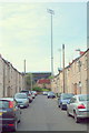
Mansfield, Notts.
A corner of the Field Mill football ground seen from elevated end of Lord Street, a cul-de-sac.
Image: © David Hallam-Jones
Taken: 13 Sep 2013
0.03 miles
2

Outswinger
Hull City's Polish winger Kamil Grosicki is about to send an outswinging corner into the goalmouth during a pre-season friendly match at Mansfield Town's One Call Stadium (formerly Field Mill). The game finished 2-2.
Image: © Neil Theasby
Taken: 20 Jul 2019
0.05 miles
3

Injury Time
Hull City's central defender Reece Burke lies injured in his own penalty box after being felled in a pre-season friendly at Mansfield Town's home stadium. The game finished 2-2.
Image: © Neil Theasby
Taken: 20 Jul 2019
0.05 miles
4
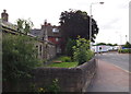
Mansfield, Notts (Portland Street)
A view of Portland Street (formerly Bull’s Head Lane) looking towards its junction with Nottingham Road. On the left are the "additional six" almshouses built in 1844 and funded by the Elizabeth Heath Charity. Although this row of cottages "for ancient ladies" was in use until the Winter of 2011/12 they are now empty and boarded up. The original single-bedroomed almshouses – twelve in number – are situated on Nottingham Road and are still inhabited. Elizabeth Heath (1617-93), a Mansfield resident and a Quaker, endowed these almshouses for women born in Mansfield or having lived in Mansfield for a substantial part of their lives and with limited assets - criteria that remain in use today. The allocation of residents i.e. "six Quakers and six church members of the established church" presumably demonstrated a wish to avoid clashing with the Anglican authorities given that Quakers were frequently shunned by most other authorities at this time?
Image: © David Hallam-Jones
Taken: 15 Jul 2012
0.08 miles
5
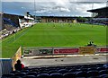
Mansfield Town's Stadium
The oldest professional football stadium in the world. It was always called Field Mill but in recent times its name has been hi-jacked by an insurance company. In the picture, a pre-season friendly in play - between Mansfield Town and Hull City A.F.C..
Image: © Neil Theasby
Taken: 20 Jul 2019
0.08 miles
6
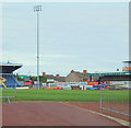
Mansfield, Notts.
Part of the Field Mill football ground, home of Mansfield Town Football Club. The club adopted the name "Mansfield Town" in 1910 and have played here since 1919. The ground was renovated in 2001 after a decision not to move to a purpose-built ground and in March 2012 the current Chairman, John Radford purchased Field Mill for the benefit of the club. This is a view from near the main entrance on Quarry Lane and the terraced houses in the centre of the picture are on Lord Street.
Image: © David Hallam-Jones
Taken: 13 Sep 2013
0.09 miles
7
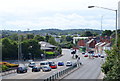
Mansfield, Notts.
A view of Nottingham Road (the A60) looking in the Ravenshead, Newstead and Nottingham direction as seen from a new-ish footbridge that crosses over Portland Street.
Image: © David Hallam-Jones
Taken: 13 Sep 2013
0.10 miles
8
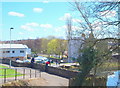
Portland Road Vicinity, Mansfield, Notts.
Pedestrians and cyclists use this descending path (with its railings) to get from Quarry Lane to Nottingham Road in the distance. Field Mill, where these observers are standing, was originally a corn mill but it was later acquired by a Nottingham hosiery company as a cotton mill and spinning was carried out between 1788-1812. Although the buildings were used for other purposes the premises after cotton spinning was discontinued, the premises were eventually purchased by the local Council and finally demolished in the 1920s. The buildings on the left are part of a large commercial laundry. The former mill pond, formed by the dammed River Maun, is now an angler's paradise and part of the Maun Valley trail.
Image: © David Hallam-Jones
Taken: 17 Apr 2016
0.12 miles
9
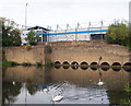
Mansfield, Notts.
Only a section of the mill pond wall and water intake conduits remain of a former mill that existed here. Field Mill was originally a corn mill that was later acquired by a Nottingham hosiery company for use as a cotton mill. Following its purchase the mill was adapted and upgraded and the mill pond increased in size. Thereafter spinning was conducted here between 1788-1812. Although the buildings were used for other purposes after its cotton spinning role ceased, the premises were eventually purchased by the local Council and finally demolished in the 1920s. The former mill pond, formed by the dammed River Maun, is now an angler's paradise and part of the Maun Valley trail. Mansfield Town Football Club's Field Mill ground providing a backdrop. Quarry Lane runs between the lower and the higher stone walls.
Image: © David Hallam-Jones
Taken: 13 Sep 2013
0.12 miles
10
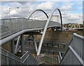
Footbridge to Shops
Close to Mansfield railway station, the pedestrian bridge over the inner ring road. It links the old town centre with the new shopping area next to the football ground.
Image: © Peter Kochut
Taken: 26 May 2005
0.12 miles